

- Usage in publication:
-
- Lookingglass Formation
- Modifications:
-
- Named
- Biostratigraphic dating
- Dominant lithology:
-
- Sandstone
- Siltstone
- Conglomerate
- Coal
- AAPG geologic province:
-
- Klamath Mountains province
- Oregon-Washington Coast Ranges province
Summary:
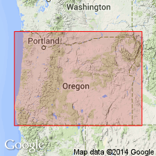
Named for Lookingglass Valley. Type section designated as exposures along Tenmile Creek from Bushnell Rock south to Tenmile Butte, Reedsport quad, Douglas Co, OR. Formation divided into three members (ascending): Bushnell Rock, Tenmile, and Olalla Creek Member (all new). "From the historical viewpoint these formations [Roseburg, Lookingglass, Flournoy] would be part of Umpqua Group; however, the major unconformity between Roseburg and Lookingglass Formations may not be in accord with group concept." p.5. Composed of rhythmically bedded sandstone and siltstone. Basal beds are coal-bearing and conglomeratic locally near base of section. Is 1570 m thick. Unconformably overlies Roseburg Formation (new). Unconformably underlies Flournoy Formation (new) or Tyee Formation. Age is early to middle Eocene based on megafossil (VENERICARDIA ARAGONA) and foraminifers. [Equivalent to middle member of Umpqua Formation as defined by Baldwin (1965) (Baldwin and Beaulieu, 1973)]
Source: GNU records (USGS DDS-6; Menlo GNULEX).

- Usage in publication:
-
- Lookingglass Formation
- Modifications:
-
- Revised
- AAPG geologic province:
-
- Klamath Mountains province
- Oregon-Washington Coast Ranges province
Summary:
Lookingglass Formation is considered to be middle formation of Umpqua Group which includes (ascending): Roseburg, Lookingglass, and Flournoy Formations. Writer considers "the apparent unconformity between Roseburg and Lookingglass, interpreted by Baldwin ... as more probably due to differences in competence of the Roseburg and the basal conglomerates of the Lookingglass." "No unconformity was observed by the writer between the Lookingglass and Flournoy." p.520. Shown on stratigraphic columns at Middle Fork Coquilla River, at North Umpqua River, and at South Fork Coquille River, OR. Age given as Eocene (early Penutian to late Ulatisian).
Source: GNU records (USGS DDS-6; Menlo GNULEX).
- Usage in publication:
-
- Lookingglass Formation
- Modifications:
-
- Not used
- AAPG geologic province:
-
- Oregon-Washington Coast Ranges province
- Klamath Mountains province
Summary:
Lookingglass Formation of Baldwin (1974) not recognized because unit is of limited extent. Rocks of Olalla Creek Member of Lookingglass Formation of Baldwin (1974) now included in White Tail Ridge Member of Umpqua Formation. Tenmile and Bushnell Rock Members are retained as members of Umpqua Formation. [members of Umpqua Formation not adopted in this paper]
Source: GNU records (USGS DDS-6; Menlo GNULEX).
For more information, please contact Nancy Stamm, Geologic Names Committee Secretary.
Asterisk (*) indicates published by U.S. Geological Survey authors.
"No current usage" (†) implies that a name has been abandoned or has fallen into disuse. Former usage and, if known, replacement name given in parentheses ( ).
Slash (/) indicates name conflicts with nomenclatural guidelines (CSN, 1933; ACSN, 1961, 1970; NACSN, 1983, 2005, 2021). May be explained within brackets ([ ]).