The National Geologic Map Database is migrating to a new infrastructure. We apologize for any service disruptions during this process.
|
|---|


- Usage in publication:
-
- Long Lake Drift
- Modifications:
-
- Named
- Dominant lithology:
-
- Till
- AAPG geologic province:
-
- Williston basin
Summary:
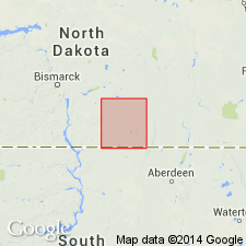
Type area designated in secs 4-9, T136N, R73W, Logan Co, ND, 10 mi southeast of Long Lake, for which unit is named, Williston basin. Long Lake extends northwest into Emmons, Kidder, and Burleigh Cos. Drifts described in this report are not lithostratigraphic units as defined by American Commission on Stratigraphic Nomenclature (1961) because drifts have been differentiated by their topographic form, geographic position, and inferred geologic history. Consists of till of Long Lake end moraine plus other associated drift that originated from same glacial ice. Lithology of the four Wisconsin drifts in study area are nearly identical; most of till is light olive gray and contains about equal amounts of clay, silt, and sand and about 5% pebbles, cobbles, and boulders. Long Lake is distinguished from older Napoleon Drift (new) by its lack of drainage integration; younger than Zeeland Drift (new). Geologic map; correlation chart. Assigned late Wisconsin (Pleistocene) age though actual age is unknown.
Source: GNU records (USGS DDS-6; Denver GNULEX).
For more information, please contact Nancy Stamm, Geologic Names Committee Secretary.
Asterisk (*) indicates published by U.S. Geological Survey authors.
"No current usage" (†) implies that a name has been abandoned or has fallen into disuse. Former usage and, if known, replacement name given in parentheses ( ).
Slash (/) indicates name conflicts with nomenclatural guidelines (CSN, 1933; ACSN, 1961, 1970; NACSN, 1983, 2005, 2021). May be explained within brackets ([ ]).