The National Geologic Map Database is migrating to a new infrastructure. We apologize for any service disruptions during this process.
|
|---|


- Usage in publication:
-
- Loma Blanca oyster horizon
- Modifications:
-
- Areal extent
- AAPG geologic province:
-
- Gulf Coast basin
Summary:
Pg. 1374-1375. Referred to as Loma Blanca oyster horizon of [F.C.] Owens. [Age is Eocene (Claiborne).]
Source: US geologic names lexicon (USGS Bull. 1200, p. 2219).
- Usage in publication:
-
- Loma Blanca tongue
- Modifications:
-
- Revised
- AAPG geologic province:
-
- Gulf Coast basin
Summary:
Pg. 259 (fig. 2), 265-266. Loma Blanca tongue of Yegua formation. Suggests that F.C. Owens' Loma Blanca sandstone member be enlarged to include all of an upper sandstone tongue of the Yegua which lithologically cannot be subdivided on American side of Rio Grande. Locally there are several thin lenses of shale, sandy shale, and red streaks, but these are not easily traced. East of Falcon is 400 feet thick but east of Laredo has completely lensed out, having interfingered with a predominantly nonmarine section of red and green bentonitic shales. [Age is Eocene (Claiborne).]
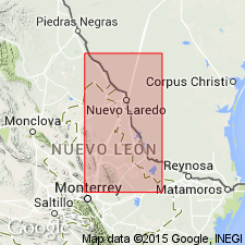
Basal beds well exposed on Loma Blanca (white hill), [approx. Lat. 26 deg. 45 min. 42 sec. N., Long. 99 deg. 41 min. 40 sec. W.], Arroyo Clareno 7.5-min quadrangle, [Zapata Co.], southwestern TX.
Source: US geologic names lexicon (USGS Bull. 1200, p. 2219).
For more information, please contact Nancy Stamm, Geologic Names Committee Secretary.
Asterisk (*) indicates published by U.S. Geological Survey authors.
"No current usage" (†) implies that a name has been abandoned or has fallen into disuse. Former usage and, if known, replacement name given in parentheses ( ).
Slash (/) indicates name conflicts with nomenclatural guidelines (CSN, 1933; ACSN, 1961, 1970; NACSN, 1983, 2005, 2021). May be explained within brackets ([ ]).