The National Geologic Map Database is migrating to a new infrastructure. We apologize for any service disruptions during this process.
|
|---|


- Usage in publication:
-
- Locust Point formation
- Modifications:
-
- Named
- Dominant lithology:
-
- Siltstone
- Sandstone
- AAPG geologic province:
-
- Cincinnati arch
Summary:
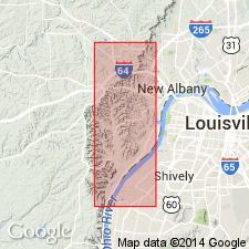
Named Locust Point formation for topographic prominence on Ohio River bluff, 1 mile south of Floyd-Harrison Co. line, IN. Consists of mainly massive or shaly siltstone in southern part of IN outcrop area. Northward the formation becomes a succession of fine-grained sandstone beds and alternating shaly zones. Fossils are rare, aside from worm marks. The average thickness is 125 ft. The Locust Point underlies the Carwood formation and overlies the New Providence formation.
Source: GNU records (USGS DDS-6; Reston GNULEX).
- Usage in publication:
-
- Locust Point†
- Modifications:
-
- Abandoned
- AAPG geologic province:
-
- Cincinnati arch
Summary:
The Locust Point and Carwood Formations of the Borden Group do not have a recognizable mutual boundary that consistently separates them outside their type areas, and they cannot be separately mapped. Together they represent parts of a depositional event that resulted in a single mappable unit, here named the Spickert Knob Formation of the Borden Group; the names Locust Point and Carwood are abandoned. The unit is described in Floyd Co., IN, where the name was used for a facies of the Locust Point Formation by Stockdale (1931). It consists of silty shale, siltstone, sandstone, and lenticular limestone. Gradationally overlies the Kenwood Member of the New Providence Shale; gradationally underlies the Floyds Knob Limestone Member of the Edwardsville Formation. Thickness at type section is 238 ft. Age is Early Mississippian (Keokuk) based on fossils.
Source: GNU records (USGS DDS-6; Reston GNULEX).
For more information, please contact Nancy Stamm, Geologic Names Committee Secretary.
Asterisk (*) indicates published by U.S. Geological Survey authors.
"No current usage" (†) implies that a name has been abandoned or has fallen into disuse. Former usage and, if known, replacement name given in parentheses ( ).
Slash (/) indicates name conflicts with nomenclatural guidelines (CSN, 1933; ACSN, 1961, 1970; NACSN, 1983, 2005, 2021). May be explained within brackets ([ ]).