The National Geologic Map Database is migrating to a new infrastructure. We apologize for any service disruptions during this process.
|
|---|


- Usage in publication:
-
- Locatelli formation
- Modifications:
-
- Original reference
- Biostratigraphic dating
- Dominant lithology:
-
- Siltstone
- Sandstone
- AAPG geologic province:
-
- California Coast Ranges province
Brabb, E.E., 1960, Geology of the Big Basin area Santa Cruz Mountains, California: Dissertation Abstracts, v. 21, no. 5, p. 1163., Stanford University PhD dissertation, 197 p., 7 pls. (incl. geol. maps, scale 1:24,000), available at https://searchworks.stanford.edu/view/1172029 and https://purl.stanford.edu/xm906tb2649
Summary:
Locatelli Formation. Oldest sedimentary rocks in area. Underlies Butano sandstone. Rests nonconformably on quartz diorite. Age is Paleocene.
Report discusses Big Basin area, Santa Cruz Mountains, western California.
Source: US geologic names lexicon (USGS Bull. 1200, p. 2207).
- Usage in publication:
-
- Locatelli formation*
- Modifications:
-
- [Principal reference]
- Biostratigraphic dating
- Dominant lithology:
-
- Siltstone
- Sandstone
- AAPG geologic province:
-
- California Coast Ranges province
Summary:
Pg. 182-184. Locatelli formation. Dark-gray, massive siltstone with few beds of interstratified sandstone. Thickness about 250 feet along Scott Creek and possibly as much as 800 feet in vicinity of Jamison Creek. Overlies quartz diorite; unconformably underlies Butano sandstone. Fossils; chiefly Foraminifera, notably CIBICIDES MARTINEZENSIS, TRITAXILINA COLEI, MARGINULINA SUBBULLATA, BULIMINA EXIGUA, and PALMULA DELICATISSIMA. Age is Paleocene (Ynezian stage of V.S. Mallory, 1959, Lower Tertiary biostratigraphy of the California Coast Ranges: Tulsa, OK, AAPG, 416 p.).
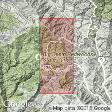
Type section [Principal reference section]: along unnamed tributary of Scott Creek, in S/2 sec. 17, T. 9 S., R. 3 W., Big Basin 7.5-min quadrangle, [near bdry. Big Basin Redwoods State Park], Santa Cruz Co., CA. Named from Locatelli Ranch, in S/2 sec. 16, T. 9 S., R. 3 W., Big Basin 7.5-min quadrangle, Santa Cruz Co., CA [Name credited to E.E. Brabb, Stanford Univ. PhD dissert., 1960.].
Outcrops of Locatelli formation limited to small patches around the crystalline core of Ben Lomond Mountain. Notable exposures on north flank of mountain where rocks were previously assigned to Butano sandstone by Banner and others (1909).
Source: Publication; GNU records (USGS DDS-6; Menlo GNULEX).
- Usage in publication:
-
- Locatelli Formation*
- Modifications:
-
- Adopted
- Overview
- AAPG geologic province:
-
- California Coast Ranges province
Summary:
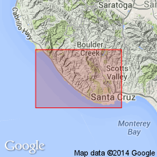
Locatelli Formation of Brabb (1960) and Cummings and others (1962) is adopted. Best exposures are in Smith Grade-Empire Grade area where unit extends over crest of Ben Lomond Mountain. Lists of mega- and microfossils included. Age is Paleocene (Ynezian Stage). Geologic map shows distribution.
Source: GNU records (USGS DDS-6; Menlo GNULEX).
For more information, please contact Nancy Stamm, Geologic Names Committee Secretary.
Asterisk (*) indicates published by U.S. Geological Survey authors.
"No current usage" (†) implies that a name has been abandoned or has fallen into disuse. Former usage and, if known, replacement name given in parentheses ( ).
Slash (/) indicates name conflicts with nomenclatural guidelines (CSN, 1933; ACSN, 1961, 1970; NACSN, 1983, 2005, 2021). May be explained within brackets ([ ]).