

- Usage in publication:
-
- Lobo formation*
- Modifications:
-
- Named
- Dominant lithology:
-
- Shale
- Limestone
- Conglomerate
- Sandstone
- AAPG geologic province:
-
- Basin-and-Range province
Summary:
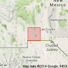
Named for Lobo Draw (designated the type locality) on east slope of Florida Mountains, Luna Co, NM in Basin-and-Range province, where 350 ft is extensively exposed. Outcrop extends for about 5 mi in the higher slopes of northern third of Florida Mountains. Lies on Montoya and El Paso limestones to north, but at Capitol Dome unit overlaps granite uplifted by a pre-Lobo fault. From that place as far as it is exposed to the southeast it lies directly on a planation surface of granite. It is overlain by agglomerate throughout this mountain range; erosional unconformity at the contact. Also occurs in northeast face of Sarten Ridge in Cooks Range and in small outcrops on Goat Ridge and Fluorite Ridge. Small exposure occurs near south end of Sarten Ridge. Consists largely of reddish and gray shale and gray to pinkish impure limestone; includes much conglomerate at base. Some basal arkosic sandstone in units overlap on the granite southeast of Capitol Dome. Ranges in thickness from 95-500 ft. No fossils found; age therefore not determined. In central Cooks Range lies unconformably on Gym limestone (new, Late Pennsylvanian age, and is also separated from the overlying Sarten sandstone (new, Early Cretaceous age) by an unconformity. Hence, age could be Pennsylvanian, Permian, Triassic, or even earliest Cretaceous. Because of unconformable relations with underlying and overlying units, however, tentatively classified as Triassic?. Geologic map.
Source: GNU records (USGS DDS-6; Denver GNULEX).
- Usage in publication:
-
- Lobo Formation
- Modifications:
-
- Overview
- Age modified
- Areal extent
- Dominant lithology:
-
- Conglomerate
- Sandstone
- Siltstone
- Mudstone
- AAPG geologic province:
-
- Pedregosa basin
- Basin-and-Range province
Summary:
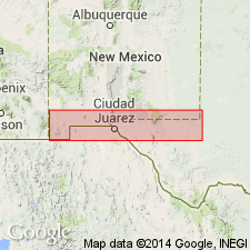
Is the principal sedimentary unit in the Klondike basin, a newly defined Laramide-age basin in southwest NM. The basin lies south of the Victorio Mountains, west of the Florida Mountains, north of the Cedar Mountain Range. Lobo identified on outcrop in the Victorio Mountains and Bisbee Hills, and in the subsurface of the basin in Luna Co. in the Basin-and-Range province, and is extended westward on outcrop and in subsurface to Hidalgo Co. in the Pedregosa basin. Cross section. Correlation chart. The basal unit, a conglomerate, unconformably overlies Lower Cretaceous Mojado Formation, unassigned Cretaceous rocks, or Silurian Fusselman Formation, depending on location in basin. Lobo is overlain by Tertiary Rubio Peak Formation at most localities, except where upper Lobo is in fault contact with the Ordovician Bliss Formation. Thickens from north to south. Is 1,400 ft thick in the Victorio Mountains where it is divisible in a basal crudely to flat bedded conglomerate of poorly sorted boulders and cobbles of sandstone, limestone, andesite clasts; conglomerate grades upward into flatbedded sandstone that is overlain by red-brown siltstone and sandstone in intervals of tens of ft thick. To south in Bisbee Hills, it is 1,800 ft thick; the basal conglomerate 140 ft thick has clasts of silty shale, mudstone, sandstone, silty limestone, dolostone and chert; the overlying sandstone is angular to subangular with carbonate and volcanic rock fragments, chert, plagioclase feldspar and traces of biotite; the upper part is dominantly a volcanic arenite. Is 1,900+ ft thick in Cockrell well, Pedregosa Co. Deposited in an alluvial-fan, fluvial, and playa environment. The conglomerates were derived from nearby. Age modified; is bracketed as early to middle Eocene. The Hidalgo which occurs as clasts in the Lobo has a fission-track age of 54.9+-2.7 Ma. The overlying Rubio Peak is 41.7 Ma.
Source: GNU records (USGS DDS-6; Denver GNULEX).
For more information, please contact Nancy Stamm, Geologic Names Committee Secretary.
Asterisk (*) indicates published by U.S. Geological Survey authors.
"No current usage" (†) implies that a name has been abandoned or has fallen into disuse. Former usage and, if known, replacement name given in parentheses ( ).
Slash (/) indicates name conflicts with nomenclatural guidelines (CSN, 1933; ACSN, 1961, 1970; NACSN, 1983, 2005, 2021). May be explained within brackets ([ ]).