

- Usage in publication:
-
- Livingston Hills Formation*
- Modifications:
-
- Named
- Dominant lithology:
-
- Conglomerate
- Graywacke
- Arkose
- Siltstone
- AAPG geologic province:
-
- Basin-and-Range province
Summary:
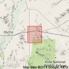
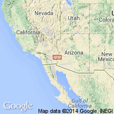
Named for Livingston Hills, T3N, Rs17 and 18W, Yuma Co, AZ in the Basin-and-Range province. These exposures designated the type locality. Divided into three members. Conglomerate member at base is a massively bedded heterogeneous boulder conglomerate. Individual conglomerate beds average 25 ft thick and they are separated by thinner lensoidal arkose or graywacke beds. Boulders derived from all the older units and they range in size from a few inches to 5+ ft; almost all are angular. Is about 4,700 ft thick at type. Grades upward into graywacke member, a member composed of gray, well-lithified, medium- to coarse-grained graywacke and conglomeratic graywacke. Bedding ranges from a few inches to several tens of ft. Graywacke member is about 5,500 ft thick. About 3,300 ft above the top of the conglomerate member is about 2,000 ft of gray siltstone and fine-grained graywacke that intertongues with the graywacke member. The siltstone is overlain by about 2,200 ft more of graywacke. Mapped in Livingston Hills and at southeast part of quad. Is younger than some unnamed continental red beds and older than Tertiary? volcanic rocks. Is assigned a Cretaceous or Tertiary age.
Source: GNU records (USGS DDS-6; Denver GNULEX).
- Usage in publication:
-
- Livingston Hills Formation
- Modifications:
-
- Overview
- AAPG geologic province:
-
- Basin-and-Range province
Summary:
Exposed in the southern Plomosa Mountains where it is 2,000 m thick and in the Livingston Hills where it is 3,600 m thick, Yuma Co, AZ in the Basin-and-Range province. The formation in these two areas though similar differs in thickness, petrology, outcrop characteristics, and contact relationships. Overlies Paleozoic rocks. Underlies mid-Tertiary volcanic rocks. In Livingston Hills: lower 1/3 is gray, poorly sorted, feldspathic matrix-supported conglomerate with clasts of granite, quartzite, carbonate interbedded with coarse- to fine-grained, poorly supported feldspathic sandstone; middle 1/3 is gray, coarse- to fine-grained sandstone; upper 1/3 is mostly siliceous siltstone. In Plomosa Hills: lower part is conglomerate of pink to red, medium- to coarse-grained, lithofeldspathic, interbeds of quartz porphyry, carbonate lenses with stromatolites; middle part is gray massive feldspathic sandstone; upper part is gray siltstone. Conglomerate variably sorted. Deposited in shallow-water, subaerial environment as debris-flow, tidal-flat, lacustrine unit. Deformed, metamorphosed, intruded by Cretaceous plutons. Fossil evidence suggests Cretaceous or Paleocene. Paleomagnetic pole near pole for Summerville Formation (Upper Jurassic). Ostracods and brachiopods collected are not age specific. May range from Permian through Paleocene age.
Source: GNU records (USGS DDS-6; Denver GNULEX).
- Usage in publication:
-
- Livingston Hills Formation
- Modifications:
-
- Not used
Summary:
Displaced in report area by McCoy Mountains Formation, a term mapped in southern Plomosa and Dome Rock Mountains, and Livingston Hills, La Paz Co, AZ in the Basin-and-Range province, and in McCoy and Palen Mountains, Riverside Co, CA in the Salton basin. Thought to be identical to upper half of McCoy Mountains Formation of Miller (1944).
Source: GNU records (USGS DDS-6; Denver GNULEX).
For more information, please contact Nancy Stamm, Geologic Names Committee Secretary.
Asterisk (*) indicates published by U.S. Geological Survey authors.
"No current usage" (†) implies that a name has been abandoned or has fallen into disuse. Former usage and, if known, replacement name given in parentheses ( ).
Slash (/) indicates name conflicts with nomenclatural guidelines (CSN, 1933; ACSN, 1961, 1970; NACSN, 1983, 2005, 2021). May be explained within brackets ([ ]).