The National Geologic Map Database is migrating to a new infrastructure. We apologize for any service disruptions during this process.
|
|---|


- Usage in publication:
-
- Little Sitkin dacite*
- Modifications:
-
- Named
- Dominant lithology:
-
- Andesite
- Rhyodacite
- AAPG geologic province:
-
- Aleutian Islands province
- Alaska Southwestern region
Summary:
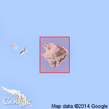
Named for widespread lava on east and south sides of Little Sitkin volcano. Type section designated in crater rim of volcano at 51 deg 57'02"N, 178 deg 32'57"E, Little Sitkin Island, Rat Islands group, Aleutian Islands, AK. Two members separately mapped from bulk of unit are named Pratt Point member (new) and West Cove member (new). Little Sitkin ranges in composition from black glassy andesite to light-gray nonporphyritic rhyodacite. Thickness ranges from 300 ft at cliffs on Pratt Point to maximum of 1000 ft. Except for surficial deposits, unit overlies all other rocks on island. Geologic map of Little Sitkin Island shows age as Quaternary.
Source: GNU records (USGS DDS-6; Menlo GNULEX).
For more information, please contact Nancy Stamm, Geologic Names Committee Secretary.
Asterisk (*) indicates published by U.S. Geological Survey authors.
"No current usage" (†) implies that a name has been abandoned or has fallen into disuse. Former usage and, if known, replacement name given in parentheses ( ).
Slash (/) indicates name conflicts with nomenclatural guidelines (CSN, 1933; ACSN, 1961, 1970; NACSN, 1983, 2005, 2021). May be explained within brackets ([ ]).