

- Usage in publication:
-
- Little Pawnee shale member
- Modifications:
-
- Original reference
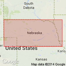
- AAPG geologic province:
-
- Salina basin
Summary:
Pg. 29. Little Pawnee shale member of Cass formation of Douglas group. Name applied to middle member of formation. Upper part of member is bluish gray; middle part is dark and somewhat fissile; lower part dark gray and fossiliferous; combined thickness 1.5 to 1.75 feet. Underlies Haskell limestone member; overlies Shoemaker limestone member. Age is Late Pennsylvanian (Virgilian).
Type locality: Little Pawnee Creek Valley, in SE/4 sec. 9, T. 12 N., R. 10 E., Saunders Co., southeastern NE.
Source: US geologic names lexicon (USGS Bull. 1200, p. 2192).
- Usage in publication:
-
- Little Pawnee Shale Member
- Modifications:
-
- Reference
- Areal extent
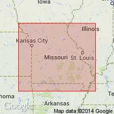
- AAPG geologic province:
-
- Forest City basin
Summary:
Pg. D525; Appendix D, p. D10. Little Pawnee Shale Member of Cass Formation of Douglas Group. At reference section, thickness about 6 feet. Upper 4.5 feet is medium-gray, reddish-brown weathering shale containing ironstone concretions; basal 1.5 feet is black to dark-gray fissile shale. Overlies Haskell Limestone Member and underlies Shoemaker Limestone Member, both of Cass Formation. (= basal Robbins Shale Member of Lawrence Formation in Kansas, Zeller, ed., 1968, Kansas Geol. Survey Bull., no. 189.) Age is Late Pennsylvanian (Virgilian).
Reference section: in cutbank on Pigeon Creek at Pigeon Hill Wildlife area, 1,200 ft south of abandoned RR bed, and 800 ft east of bridge on I-29, in SW/4 NW/4 NW/4 sec. 24, T. 56 N., R. 35 W., 3 mi south of intersection of I-29 and I-229, and 8 mi southeast of St. Joseph City Hall, St. Joseph South 7.5-min quadrangle, Buchanan Co., MO.
Source: Publication.
For more information, please contact Nancy Stamm, Geologic Names Committee Secretary.
Asterisk (*) indicates published by U.S. Geological Survey authors.
"No current usage" (†) implies that a name has been abandoned or has fallen into disuse. Former usage and, if known, replacement name given in parentheses ( ).
Slash (/) indicates name conflicts with nomenclatural guidelines (CSN, 1933; ACSN, 1961, 1970; NACSN, 1983, 2005, 2021). May be explained within brackets ([ ]).