The National Geologic Map Database is migrating to a new infrastructure. We apologize for any service disruptions during this process.
|
|---|


- Usage in publication:
-
- Little Natches member
- Modifications:
-
- Original reference
- Dominant lithology:
-
- Sand
- Shale
- AAPG geologic province:
-
- Arkla basin
Summary:
Pg. 87, 101-109, pls. 3, 8 (fig. 2). Little Natches member of Cook Mountain formation. Consists of a series of sands and shales with weathered zones of greensand and calcareous shale in lower part; sands and lignitic chocolate-brown shales in upper part differ little from overlying Cockfield except that sands contain casts of macrofossils and the shale contains agglutinated types of foraminifers. Thickness in southern part of Winn Parish 60 to 70 feet; in northern part thickness approximately 50 feet, and here shales with irregular zones of fossiliferous ironstone replace the fossiliferous sands that are present farther south. Overlies Saline Bayou member. Age is Eocene (Claiborne).
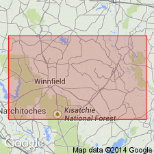
Type section: southwest corner of NE/4 NE/4 sec. 15, T. 9 N., R. 6 W., Winn Parish, along U.S. Highway 71, about 0.25 mi southeast of Little Natches Bayou, northwestern LA.
Source: US geologic names lexicon (USGS Bull. 1200, p. 2191).
For more information, please contact Nancy Stamm, Geologic Names Committee Secretary.
Asterisk (*) indicates published by U.S. Geological Survey authors.
"No current usage" (†) implies that a name has been abandoned or has fallen into disuse. Former usage and, if known, replacement name given in parentheses ( ).
Slash (/) indicates name conflicts with nomenclatural guidelines (CSN, 1933; ACSN, 1961, 1970; NACSN, 1983, 2005, 2021). May be explained within brackets ([ ]).