The National Geologic Map Database is migrating to a new infrastructure. We apologize for any service disruptions during this process.
|
|---|


- Usage in publication:
-
- Little Elm tongue
- Modifications:
-
- Original reference
- Dominant lithology:
-
- Shale
- AAPG geologic province:
-
- Ouachita folded belt
Summary:
Pg. 61-62. Little Elm tongue of Templeton member of Woodbine formation. Mostly dark shale. Thickness as much as 20 feet. Younger than Six Flags limestone (new) on Timber Creek. Older than bentonitic submember of Britton member of Eagle Ford. Age is Late Cretaceous.
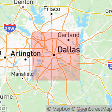
Type locality: along shores of Garza-Little Elm Reservoir near settlement of Little Elm where highway crosses drowned arm of Little Elm Creek, northeastern TX.
Alternate type localities: Timber Creek, on highway south Lewisville; Prairie Creek, at cemetery in northeastern edge of Lewisville.
Source: US geologic names lexicon (USGS Bull. 1350, p. 429).
For more information, please contact Nancy Stamm, Geologic Names Committee Secretary.
Asterisk (*) indicates published by U.S. Geological Survey authors.
"No current usage" (†) implies that a name has been abandoned or has fallen into disuse. Former usage and, if known, replacement name given in parentheses ( ).
Slash (/) indicates name conflicts with nomenclatural guidelines (CSN, 1933; ACSN, 1961, 1970; NACSN, 1983, 2005, 2021). May be explained within brackets ([ ]).