

- Usage in publication:
-
- Little Brazos limestone lentil
- Modifications:
-
- Original reference
- Dominant lithology:
-
- Limestone
- AAPG geologic province:
-
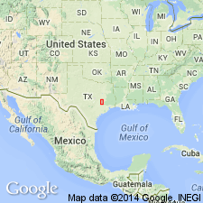
- East Texas basin
- Gulf Coast basin
Summary:
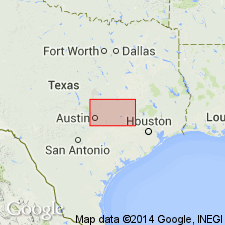
Pg. 78, 92. Little Brazos limestone lentil. In Crockett clay member of Cook Mountain formation, from 24 to 28 feet above Moseley limestone lentil and from 65 to 70 feet below top of Crockett member is another impure argillaceous glauconitic limestone, 2 to 4 feet thick, sometimes occurring as a concretionary bed. It is here named Little Brazos limestone lentil, because it is best exposed and has its best faunal representation along Little Brazos River in neighborhood of the old interurban crossing on W.T. James estate, 70 acres, W. Matthis survey, about 1.4 miles northeast of Bryan Junction, [Mumford 15-min quadrangle, Brazos County]. Also exposed at other places in Brazos, Robertson, and Burleson Counties, eastern central Texas. The clays separating Little Brazos limestone from overlying Yegua formation are gray, buff, and gypsiferous. [Age is middle Eocene.]
[Exposure along Little Brazos River 1.4 mi northeast of Varisco, approx. Lat. 30 deg. 39 min. 40 sec. N., Long. 96 deg. 30 min. 36 sec. W., Mumford 7.5-min quadrangle, Brazos Co., eastern central TX; see also Army Corps Eng. 1919 ed. Mumford 15-min quadrangle (Univ. Texas-Austin Perry-Castaneda Library historical map collection, ACME Mapper 2.0, USGS historical topographic map collection TopoView, USGS GNIS database; accessed July 3, 2012).]
Source: US geologic names lexicon (USGS Bull. 896, p. 1193).

- Usage in publication:
-
- Little Brazos limestone
- Modifications:
-
- Revised
- AAPG geologic province:
-
- East Texas basin
- Gulf Coast basin
Summary:
Pg. 612. Little Brazos limestone in Crockett formation of Claiborne group. Showed Little Brazos limestone lying higher in the Crockett than Moseley limestone. [Age is middle Eocene.]
Source: US geologic names lexicon (USGS Bull. 896, p. 1193).
- Usage in publication:
-
- Little Brazos Limestone Lentil
- Modifications:
-
- Areal extent
- AAPG geologic province:
-
- East Texas basin
- Gulf Coast basin
Summary:
Little Brazos Limestone Lentil of Cook Mountain Formation of Claiborne Group. Age is Eocene.
Not separately mapped. Occurs in Little Brazos River Valley.
Source: Publication.
For more information, please contact Nancy Stamm, Geologic Names Committee Secretary.
Asterisk (*) indicates published by U.S. Geological Survey authors.
"No current usage" (†) implies that a name has been abandoned or has fallen into disuse. Former usage and, if known, replacement name given in parentheses ( ).
Slash (/) indicates name conflicts with nomenclatural guidelines (CSN, 1933; ACSN, 1961, 1970; NACSN, 1983, 2005, 2021). May be explained within brackets ([ ]).