

- Usage in publication:
-
- Lithopolis member
- Modifications:
-
- Original reference
- Dominant lithology:
-
- Sandstone
- Shale
- AAPG geologic province:
-
- Appalachian basin
Summary:
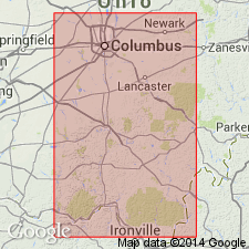
Pg. 656, 657, 670. Lithopolis member of Cuyahoga formation. Thin, horizontal, interbedded sandstones and shales; sandstones usually light gray or bluish, moderately fine-grained and evenly bedded; shales argillaceous and usually sandy and gray. Thickness 118 to 140 and possibly 200 feet. Basal member of Cuyahoga formaiton in central Fairfield and Hocking Counties, south-central Ohio. Underlies Fairfield member of Cuyahoga and overlies Sunbury shale. Lower 50 feet = Buena Vista member of Prosser and Cumings. Age is Mississippian.
Named from Lithopolis, Fairfield Co., south-central OH.
Source: US geologic names lexicon (USGS Bull. 896, p. 1192).
- Usage in publication:
-
- Lithopolis siltstone member
- Modifications:
-
- Revised
- AAPG geologic province:
-
- Appalachian basin
Summary:
Pg. 43, 45. [Lithopolis siltstone member of Cuyahoga formation.] Included in Hocking Valley conglomerate facies of Cuyahoga formation and name emended to Lithopolis siltstone member [on p. 45 unit is referred to as sandstone member]. Estimated thickness 180 to 200 feet. Underlies Fairfield sandstone member, contact concealed. Age is Early Mississippian (Kinderhook).
Source: US geologic names lexicon (USGS Bull. 1200, p. 2184-2185).
For more information, please contact Nancy Stamm, Geologic Names Committee Secretary.
Asterisk (*) indicates published by U.S. Geological Survey authors.
"No current usage" (†) implies that a name has been abandoned or has fallen into disuse. Former usage and, if known, replacement name given in parentheses ( ).
Slash (/) indicates name conflicts with nomenclatural guidelines (CSN, 1933; ACSN, 1961, 1970; NACSN, 1983, 2005, 2021). May be explained within brackets ([ ]).