The National Geologic Map Database is migrating to a new infrastructure. We apologize for any service disruptions during this process.
|
|---|


- Usage in publication:
-
- Lithic Ridge Tuff*
- Modifications:
-
- Overview
- AAPG geologic province:
-
- Great Basin province
Summary:
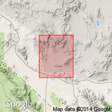
Is an ash-flow tuff, a cooling unit, gray, yellow, green, partly welded. Contains quartz, potassium feldspar, plagioclase, hornblende, biotite, and sphene. Rich in lithic inclusions (as much as 50 percent) that are composed of rhyolitic to intermediate lavas. Thin ash-flow tuff about 9 m thick intercalated with tuff in subsurface. Intercalated with rocks of Pavits Spring south of Skull Mountain and Little Skull Mountain. Maximum exposed thickness 275 m. Is 292 m in a drillhole. Is younger than the rhyolite, quartz latite, and dacite lava, and flow breccia of drillhole USW-G2. Is older than dacite lava and older than the dacite lava and flow breccia in drillhole USW-G1. Mapped in southeast part of area and shown in subsurface on cross sections, Nye Co, NV in the Great Basin province.
Source: GNU records (USGS DDS-6; Denver GNULEX).
- Usage in publication:
-
- Lithic Ridge Tuff*
- Modifications:
-
- Named
- Dominant lithology:
-
- Tuff
- AAPG geologic province:
-
- Great Basin province
Summary:
Named for exposures at Lithic Ridge (the type locality), 1 km southeast of Topopah Spring, Topopah Spring 7 1/2 min quad, Nye Co, NV, Great Basin province. Included in lower part of tuff of Calico Hills in earlier reports. Is the only unit older than Paintbrush Tuff known to occur in both northern and southern parts of Nevada Test Site. Completely penetrated in drillholes below 4,000 ft; subsurface thicknesses range from 679 to 997 ft. Is 800 ft thick at type. Crops out at south edge of Pahute Mesa in canyon between Blacktop Buttes and Split Ridge. Overlapped by younger tuffs; base not exposed. Is stratigraphically above unnamed quartz latitic tuff beneath Grouse Canyon Member of Belted Range Tuff. Distribution and thickness map. Is older than some unnamed dacitic lava. Has about 3 percent phenocrysts, a few percent lithic fragments in lower part, and about 9 percent phenocrysts and 10 percent lithic fragments in upper part; groundmass is white, zeolitic. In drillholes, most of tuff is slightly to partially welded, zeolitized, and argillized. Moderately welded near top and contains 18 percent phenocrysts. Lithic fragments (predominant pilotaxitic) and phenocrysts make this an excellent marker. Has an approximate age of 13.8 m.y. Geologic map. Stratigraphic chart.
Source: GNU records (USGS DDS-6; Denver GNULEX).
- Usage in publication:
-
- Lithic Ridge Tuff*
- Modifications:
-
- Overview
- Geochronologic dating
- AAPG geologic province:
-
- Great Basin province
Summary:
Within southwest Nevada volcanic field, Nye Co, NV, Great Basin province, units previously of formation rank are raised to group rank to allow for combining petrographically, geochemically, and temporally related lava flows and nonwelded tuffs with the principal correlative welded ash-flow tuff sheets (formerly members of the previous formation-rank tuffs). The ash-flow sheets are raised to formation rank and designated as "Tuff." Lithic Ridge, however, retains its original formation rank. Younger than lava of Tram Ridge; older than comendite of Split Ridge (formerly rhyolite of Split Ridge; retains informal status) of Belted Range. Nomenclature chart (table 1). 40Ar/39Ar age date of 13.85 +/-0.07 Ma (Miocene) determined on sanidine (table 3).
Source: GNU records (USGS DDS-6; Denver GNULEX).
For more information, please contact Nancy Stamm, Geologic Names Committee Secretary.
Asterisk (*) indicates published by U.S. Geological Survey authors.
"No current usage" (†) implies that a name has been abandoned or has fallen into disuse. Former usage and, if known, replacement name given in parentheses ( ).
Slash (/) indicates name conflicts with nomenclatural guidelines (CSN, 1933; ACSN, 1961, 1970; NACSN, 1983, 2005, 2021). May be explained within brackets ([ ]).