The National Geologic Map Database is migrating to a new infrastructure. We apologize for any service disruptions during this process.
|
|---|


- Usage in publication:
-
- Lissie Formation
- Modifications:
-
- Mapped 1:250k (revised 1992 edition)
- Dominant lithology:
-
- Clay
- Silt
- Sand
- AAPG geologic province:
-
- Gulf Coast basin
Summary:
Pamphlet [p. 2]. Lissie Formation. Upper part [mapped as Montgomery Formation, 1968 edition], clay, silt, sand, and very minor siliceous gravel of granule and small pebble size, gravel more abundant northwestward, locally calcareous, concretions of calcium carbonate, iron oxide, and iron-manganese oxides common in zone of weathering; fluviatile; surface fairly flat and featureless except for numerous rounded shallow depressions and pimple mounds. Lower part [mapped as Bentley Formation, 1968 edition], clay, silt, sand, and minor amount of gravel; gravel slightly coarser than in upper part, noncalcareous, iron oxide concretions more abundant than in upper part; fluviatile; very gently rolling. Total thickness 200+/- feet. Unconformably overlies Willis Formation and unconformably underlies Beaumont Formation. Age is Pleistocene.
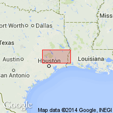
[Mapped mostly in central and eastern parts of map sheet in Hardin, Harris, Jasper, Liberty, Montgomery, Newton, Polk, San Jacinto, and Tyler Cos., TX.]
Source: Publication.

- Usage in publication:
-
- Lissie Formation
- Modifications:
-
- Mapped 1:250k
- Dominant lithology:
-
- Sand
- Silt
- Clay
- Gravel
- AAPG geologic province:
-
- Gulf Coast basin
Summary:
Lissie Formation. Sand, silt, clay, and minor amount of gravel. Characterized by "moderate permeability, moderate drainage, and high shear strength; geologic units include meanderbelt, levee, crevasse splay, and distributary sands and flood-basin mud over meanderbelt sand." Thickness about 200 feet. Overlies Willis Formation; underlies Beaumont Formation and younger Quaternary deposits. Age is Pleistocene.
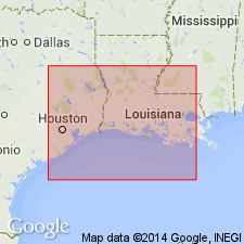
Mapped in De Witt, Victoria, Jackson, Lavaca, Colorado, Wharton, Austin, and Waller Cos., southeastern TX.
Source: Modified from GNU records (USGS DDS-6; Denver GNULEX).

- Usage in publication:
-
- Lissie Formation
- Modifications:
-
- Mapped 1:250k
- Dominant lithology:
-
- Sand
- Silt
- Clay
- AAPG geologic province:
-
- Gulf Coast basin
Summary:
Lissie Formation. Sand, silt, clay, and minor amount of gravel, mostly mud veneer over meanderbelt sand; surface gently rolling; only lower part present. [Thickness not stated.] Lies above Goliad Formation (Pliocene) and below Holocene alluvium. Age is Pleistocene.
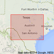
[Mapped in Jim Wells and Live Oak Cos., southern TX.]
Source: Publication.
- Usage in publication:
-
- Lissie Formation*
- Modifications:
-
- Areal extent
- AAPG geologic province:
-
- Gulf Coast basin
Summary:
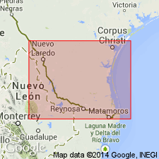
Includes three facies--coarse-grained channel (10-25 m thick), fine-grained channel (10-25 m thick, 100+ m thick in subsurface), and fine-grained overbank (55-65 m thick). Outcrop area extends into Austin and Monterrey quadrangles to the south. These three maps show the exposed extent of the Beaumont. Of middle Pleistocene age.
Source: GNU records (USGS DDS-6; Denver GNULEX).
- Usage in publication:
-
- Lissie Formation*
- Modifications:
-
- Areal extent
- AAPG geologic province:
-
- Gulf Coast basin
Summary:
Lissie Formation. Outcrop area extends into the White Lake 4 x 6 degrees quadrangle to the north and the Monterrey 4 x 6 degrees quadrangle to the south; together, these maps show the extent of the formation. Three units mapped: alluvium, about 60 m thick; alluvial sand, silt, and clay, 10 to 100+ m thick; and alluvial silt and clay, 55 to 65 m thick. Disconformably overlies Willis Formation. Facies include: meanderbelt, levee, crevasse splay, distributary sand, flood-basin mud, point bars, dunes, backswamp and lake deposits. Age is middle Pleistocene; contains Pleistocene vertebrate fauna.
Source: Modified from GNU records (USGS DDS-6; Denver GNULEX).
- Usage in publication:
-
- Lissie Formation*
- Modifications:
-
- Areal extent
- AAPG geologic province:
-
- Gulf Coast basin
Summary:
Mapped as an undifferentiated unit because distributary and interdistributary facies too small in area to map separately. Is about 60 m thick. Outcrop area shown on this map connects with Austin and White Pine 4 deg x 6 deg maps to north. These maps show the exposed extent of the Lissie in TX Gulf Coast basin. Contains vertebrate fauna. Of middle Pleistocene age.
Source: GNU records (USGS DDS-6; Denver GNULEX).
For more information, please contact Nancy Stamm, Geologic Names Committee Secretary.
Asterisk (*) indicates published by U.S. Geological Survey authors.
"No current usage" (†) implies that a name has been abandoned or has fallen into disuse. Former usage and, if known, replacement name given in parentheses ( ).
Slash (/) indicates name conflicts with nomenclatural guidelines (CSN, 1933; ACSN, 1961, 1970; NACSN, 1983, 2005, 2021). May be explained within brackets ([ ]).