

- Usage in publication:
-
- Linden limestone
- Modifications:
-
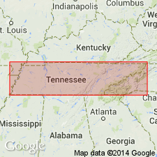
- Named
- Dominant lithology:
-
- Limestone
- AAPG geologic province:
-
- Cincinnati arch
Safford, J.M., and Killebrew, J.B., 1876, Elementary geology of Tennessee: Nashville, TN, 255 p.
Summary:
Blue, highly fossiliferous thin-bedded, sometimes shaly limestone here named Linden limestone. 0 to 100 ft thick. Underlies Black shale and overlies Clifton limestone at Linden, Perry Co. Age is Early Devonian (Helderbergian).
Source: GNU records (USGS DDS-6; Reston GNULEX).
- Usage in publication:
-
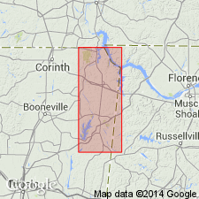
- Linden Group
- Modifications:
-
- Areal extent
- AAPG geologic province:
-
- Warrior basin
Summary:
Present report recognizes the Linden Group as including the Ross Formation and the Flat Gap Limestone as described by Wilson (1949). Ross Formation is the only portion of the Linden Group represented at the surface of Tishomingo Co. The overlying Flat Gap Limestone occurs in isolated synclinal basins in the subsurface of the study area.
Source: GNU records (USGS DDS-6; Reston GNULEX).
For more information, please contact Nancy Stamm, Geologic Names Committee Secretary.
Asterisk (*) indicates published by U.S. Geological Survey authors.
"No current usage" (†) implies that a name has been abandoned or has fallen into disuse. Former usage and, if known, replacement name given in parentheses ( ).
Slash (/) indicates name conflicts with nomenclatural guidelines (CSN, 1933; ACSN, 1961, 1970; NACSN, 1983, 2005, 2021). May be explained within brackets ([ ]).