The National Geologic Map Database is migrating to a new infrastructure. We apologize for any service disruptions during this process.
|
|---|


- Usage in publication:
-
- Lincoln Creek Formation*
- Modifications:
-
- Named
- Biostratigraphic dating
- Dominant lithology:
-
- Siltstone
- Sandstone
- AAPG geologic province:
-
- Oregon-Washington Coast Ranges province
Summary:
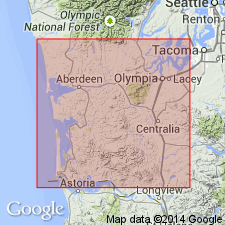
Named for exposures along Lincoln Creek, northwestern Lewis Co. WA. Replaces Lincoln Formation of Weaver (1912) which name was pre-empted. [Note name Lincoln Creek Formation was first used by Arnold and Hannibal (1913)]. Type section designated as exposures along Chehalis River from Galvin to Helsing Junction, Lewis and Thurston Cos. Reference sections are at Canyon River, along HWY 9 in vicinity of Porter, Pe Ell-Doty, and Willapa River. Crops out within or underlies about 1500 sq mi in Grays Harbor basin. Consists of tuffaceous siltstone and fine-grained sandstone. Along east edge of basin consists mainly of basaltic sandstone member with interbeds of pyroclastic rocks; member is about 1500 ft thick east of Chehalis but thins to south and west. Thickness of formation ranges from about 2000 ft to 9000 ft. In eastern part conformably overlies Skookumchuck Formation; in areas of pre-Oligocene relief overlaps older sedimentary rocks and locally unconformably overlies volcanic rocks of Crescent Formation. Underlies Astoria(?) Formation. Molluscan and foraminiferal collections indicate age range from late Eocene to early Miocene.
Source: GNU records (USGS DDS-6; Menlo GNULEX).
- Usage in publication:
-
- Lincoln Creek(?) Formation*
- Modifications:
-
- Areal extent
- AAPG geologic province:
-
- Puget Sound province
Summary:
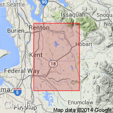
Lincoln Creek(?) Formation exposed along Cedar River in and east of city of Renton, WA over distance of 1 mi; shown as unnamed sedimentary rocks on map by Mullineaux (1965). Consists of about 1600 ft of conglomeratic sandstone in lower part and mudstone and shale interbedded with sandstone and a little conglomerate in upper part. Is thick bedded in lower part, thin and thick bedded in upper part. Formation derived from mafic volcanic rocks. Overlies Renton Formation with conformity or slight disconformity. Underlies Quaternary deposits. Few mi both to northeast and northwest, Renton underlies 1000's of ft of Oligocene andesitic sedimentary rocks, suggesting that Lincoln Creek(?) near Renton is only basal remnant of formerly much thicker section. Poorly preserved marine fossils indicate that Lincoln Creek(?) Formation is Eocene or Oligocene age.
Source: GNU records (USGS DDS-6; Menlo GNULEX).
For more information, please contact Nancy Stamm, Geologic Names Committee Secretary.
Asterisk (*) indicates published by U.S. Geological Survey authors.
"No current usage" (†) implies that a name has been abandoned or has fallen into disuse. Former usage and, if known, replacement name given in parentheses ( ).
Slash (/) indicates name conflicts with nomenclatural guidelines (CSN, 1933; ACSN, 1961, 1970; NACSN, 1983, 2005, 2021). May be explained within brackets ([ ]).