

- Usage in publication:
-
- Lighthouse Point Member*
- Modifications:
-
- Named
- Dominant lithology:
-
- Greenstone
- AAPG geologic province:
-
- Lake Superior region
- Wisconsin arch
Summary:
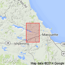
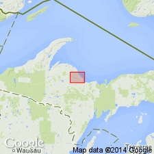
Pg. 8. Lighthouse Point Member, in upper part of Mona Schist. Present in Marquette 7.5-min quadrangle, Marquette County, northwestern Michigan (Lake Superior region). Corresponds virtually to Williams' (1891, USGS Bull. 62) banded greenstones. Is characteristically a more or less distinctly layered amphibole schist; some massive greenstone and felsitic rock and small amounts of mafic meta-agglomerate are intercalated with the layered amphibole schist. Lower part of member, formerly Williams' Eureka series, consists mainly of chloritic slate. Thickness ranges from approximately 4,500 to 11,600(?) feet; maximum thickness, near west edge of quadrangle, is questionable (could be folded). Intruded by Compeau Creek Gneiss (new). Age is early Precambrian. Report includes geologic maps, correlation chart, mineralogic analyses.
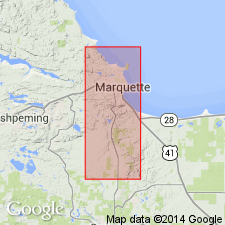
Type locality: Lighthouse Point in easternmost part of city of Marquette, Marquette 7.5-min quadrangle, Marquette Co., Northern Peninsula, northwestern MI.
Source: Publication; Changes in stratigraphic nomenclature, 1968 (USGS Bull. 1294-A, p. A11).
- Usage in publication:
-
- Lighthouse Point Member*
- Modifications:
-
- Overview
- Dominant lithology:
-
- Amphibolite
- AAPG geologic province:
-
- Lake Superior region
Summary:
Is uppermost member of Mona Schist (lower Precambrian). Is mapped in westward-broadening belt crossing northern part of Negaunee quadrangle, Marquette Co, MI (Lake Superior region). Belt is 3,500 ft wide at east edge of quad and nearly 17,000 ft wide in north-central part. Forms gently east-southeast plunging syncline in eastern area. Overlies sheared rhyolite tuff member of Mona Schist. Map unit described as dark-green fine-grained layered amphibolite; near contact with Compeau Creek Gneiss less distinctly layered and streaked with light-gray felsic material; member at least 8,500 ft thick. Amphibolite consists of alternating layers of fine-grained dark-green hornblende-rich rock and lighter colored plagioclase-rich rocks; disseminated epidote locally conspicuous and epidote veinlets not uncommon; contrasting dark-green and lighter colored layers 1/4 to 1/2 in thick and commonly segregated into bands as thick as 6 in; long, lozenge-shaped structures similar to boudins or flattened pillows in some outcrops. Felsic augen zone near (and parallel to) contact with Compeau Creek Gneiss is conspicuous and seemingly consistent relation.
Source: GNU records (USGS DDS-6; Denver GNULEX).
- Usage in publication:
-
- Lighthouse Point Basalt*
- Modifications:
-
- Revised
- Redescribed
- AAPG geologic province:
-
- Wisconsin arch
Summary:
Lighthouse Point Member of Mona Schist here revised and redefined as Lighthouse Point Basalt. Unit is stratigraphically extended to include all mafic rocks except gabbro in the lithostratigraphic block north of the Dead River shear zone. Rocks south of the Dead River shear zone previously mapped as part of the Lighthouse Point are here considered part of the restricted Mona Schist. Lighthouse Point Basalt consists dominantly of pillowed and massive tholeiitic basalt flows, and includes four thin informal units (ascending): Nash Creek glomerophyric basalt unit near base, Reany Lake pyroclastic unit and immediately overlying Fire Center mine iron-formation unit near middle, and Hills Lakes pyroclastic unit near the top. Covers approximately 150 square km. Minimum stratigraphic thickness now estimated at 7,100 m.
Source: GNU records (USGS DDS-6; Reston GNULEX).
For more information, please contact Nancy Stamm, Geologic Names Committee Secretary.
Asterisk (*) indicates published by U.S. Geological Survey authors.
"No current usage" (†) implies that a name has been abandoned or has fallen into disuse. Former usage and, if known, replacement name given in parentheses ( ).
Slash (/) indicates name conflicts with nomenclatural guidelines (CSN, 1933; ACSN, 1961, 1970; NACSN, 1983, 2005, 2021). May be explained within brackets ([ ]).