The National Geologic Map Database is migrating to a new infrastructure. We apologize for any service disruptions during this process.
|
|---|


- Usage in publication:
-
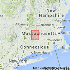
- Leyden argillite*
- Modifications:
-
- Named
- Dominant lithology:
-
- Argillite
- Schist
- AAPG geologic province:
-
- New England province
Summary:
Named the Leyden argillite in central MA and southeastern VT for Leyden Township, Franklin Co., MA. Consists of dark, coarse slate or fine-grained mica schist with chiastolitic contact zone at base. Thickness is 300 feet. Overlies Conway schist. Unit is widespread in VT. The Leyden is of Silurian(?) age.
Source: GNU records (USGS DDS-6; Reston GNULEX).

- Usage in publication:
-
- Leyden Argillite
- Modifications:
-
- Age modified
- Biostratigraphic dating
- AAPG geologic province:
-
- New England province
Summary:
The age of the Leyden Argillite is changed to Early Devonian based on brachiopods.
Source: GNU records (USGS DDS-6; Reston GNULEX).
For more information, please contact Nancy Stamm, Geologic Names Committee Secretary.
Asterisk (*) indicates published by U.S. Geological Survey authors.
"No current usage" (†) implies that a name has been abandoned or has fallen into disuse. Former usage and, if known, replacement name given in parentheses ( ).
Slash (/) indicates name conflicts with nomenclatural guidelines (CSN, 1933; ACSN, 1961, 1970; NACSN, 1983, 2005, 2021). May be explained within brackets ([ ]).