

- Usage in publication:
-
- Lewiston Peak member
- Modifications:
-
- Named
- Dominant lithology:
-
- Limestone
- Chert
- AAPG geologic province:
-
- Wasatch uplift
- Great Basin province
Summary:
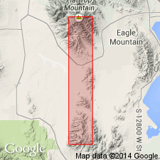
Named as a member (1 of 5) of Oquirrh formation for exposures at Lewiston Peak in Utah Co., UT on the Wasatch uplift. Mapped (geologic maps) also in adjacent Tooele Co., UT in the Great Basin province. Type locality is in secs. 28 and 29, T 5 S, R 3 W along the Utah-Tooele Co. line where section 1,409 ft thick measured. Conformably overlies the newly named Cedar Fort member of Oquirrh. Conformably underlies the newly named Pole Canyon member, upper member of the Oquirrh. Both contacts are sharp. Lewiston Peak is in contact with orthoquartzite and clastics unlike the cherty and "burnt chert" of the Lewiston Peak. Forms the west limb of the Pole Canyon syncline. Most distinctive lithology is the black, dark sooty-gray and dark black-brown case-hardened siliceous limestone and impure calcareous chert in 1" to 4" bands, discontinuous lenses, nodules, blebs, and stringers. These distinctive lithologies alternate with crystalline dark gray, fine textured bioclastic limestones that weather medium gray. Some of these gray limestones are argillaceous to shaly. The bioclastic limestones contain fusulinids, bryozoans, brachiopods, solitary corals. Bedding varies from thin to thick to massive. Ledge and bench former. Fusulinids (listed) indicate Missourian age or Late Pennsylvanian age.
Source: GNU records (USGS DDS-6; Denver GNULEX).
For more information, please contact Nancy Stamm, Geologic Names Committee Secretary.
Asterisk (*) indicates published by U.S. Geological Survey authors.
"No current usage" (†) implies that a name has been abandoned or has fallen into disuse. Former usage and, if known, replacement name given in parentheses ( ).
Slash (/) indicates name conflicts with nomenclatural guidelines (CSN, 1933; ACSN, 1961, 1970; NACSN, 1983, 2005, 2021). May be explained within brackets ([ ]).