

- Usage in publication:
-
- Leidy Formation*
- Modifications:
-
- Named
- Dominant lithology:
-
- Gravel
- Claystone
- Clay
- Sand
- Sandstone
- Shale
- AAPG geologic province:
-
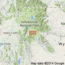
- Yellowstone province
Summary:
Name applied to some rocks formerly mapped as landslide and glacial deposits. Named for Mount Leidy, highest peak in Mount Leidy Highlands, Teton Co. Type section designated on north side of Gros Ventre River, 12 mi south-southwest of Mount Leidy, secs 1 and 12, T42N, R114W, Teton Co. Can be mapped along Gros Ventre River valley and its tributaries, and North and South Forks of Fish Creek, Teton Co, WY, Yellowstone province. Was deposited for 40 mi along river behind an ice dam at mouth of Gros Ventre canyon. Exposed (distribution map) in isolated outcrops, rarely more than 1.5 mi long. Deposited at type on irregular surface of Morrison? Formation. Can rest with angular unconformity on rocks that range from Pennsylvanian to early Eocene age. Only deposits known to overlie Leidy are younger Pleistocene tills. Ranges between 400 ft (at type) to 900 ft thick. Consists (measured section at type) of: brown to tan sand and interbedded gray gravel mostly of quartzite clasts, some granite clasts in lower part; interbedded brown claystone, tan to gray very fine to fine sand, gravel with quartzite and granite clasts in middle part; brown to dark gray claystone with scattered quartzite, chert, siltstone, granite pebbles in upper part. One interval of till. Supports selenium-converter plants. Palynomorph fossils. Has normal magnetic polarity compatible with an age <750,000 yrs. Pleistocene age. Of glacial, fluvial, lacustrine origin.
Source: GNU records (USGS DDS-6; Denver GNULEX).
For more information, please contact Nancy Stamm, Geologic Names Committee Secretary.
Asterisk (*) indicates published by U.S. Geological Survey authors.
"No current usage" (†) implies that a name has been abandoned or has fallen into disuse. Former usage and, if known, replacement name given in parentheses ( ).
Slash (/) indicates name conflicts with nomenclatural guidelines (CSN, 1933; ACSN, 1961, 1970; NACSN, 1983, 2005, 2021). May be explained within brackets ([ ]).