

- Usage in publication:
-
- Leakesville Formation
- Modifications:
-
- Named
- Dominant lithology:
-
- Claystone
- Shale
- Siltstone
- Sandstone
- Conglomerate
- AAPG geologic province:
-
- Piedmont-Blue Ridge province
- Dan River-Danville basin
Summary:
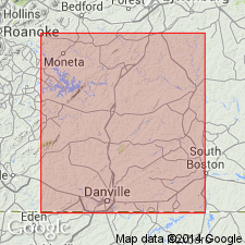
The Leakesville Formation is here named for predominantly red and black claystones, shales, siltstones, sandstones, and conglomerates which crop out in the northern west-central, and southern parts of the Danville basin, VA. It is divided into the intertonguing Cow Branch and Cascade Station Members on the basis of color. Overlies older crystalline rocks and is terminated on the east and west by faults. Interfingers with the arkosic facies of the time equivalent Dry Fork Formation. Disconformably underlies the Cedar Forest Formation. Thickness at type section is 1,100 ft (330 m). Age is Late Triassic.
Source: GNU records (USGS DDS-6; Reston GNULEX).
- Usage in publication:
-
- Leakesville Formation
- Modifications:
-
- Not used
- AAPG geologic province:
-
- Piedmont-Blue Ridge province
- Dan River-Danville basin
Summary:
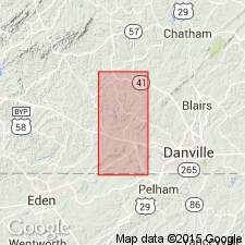
The Cow Branch Member of the Leakesville Formation, revised as the Cow Branch Formation of the Dan River Group in the Dan River basin, North Carolina, by Thayer (1970), is here brought back into the Danville basin, Virginia, as the Cow Branch Formation. [No reference is made to the Leakesville.]
Source: GNU records (USGS DDS-6; Reston GNULEX).
For more information, please contact Nancy Stamm, Geologic Names Committee Secretary.
Asterisk (*) indicates published by U.S. Geological Survey authors.
"No current usage" (†) implies that a name has been abandoned or has fallen into disuse. Former usage and, if known, replacement name given in parentheses ( ).
Slash (/) indicates name conflicts with nomenclatural guidelines (CSN, 1933; ACSN, 1961, 1970; NACSN, 1983, 2005, 2021). May be explained within brackets ([ ]).