

- Usage in publication:
-
- Lead Creek limestone
- Modifications:
-
- Named
- Dominant lithology:
-
- Limestone
- AAPG geologic province:
-
- Illinois basin
Summary:
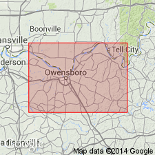
Name Lead Creek limestone introduced for three or four ledges of limestone ranging in thickness from 8 to 10 ft, extending through an interval of 30 to 40 ft in Coal Measures of Tell City and Owensboro quads. Base is 255 ft above top of conglomerate forming basal part of Pennsylvanian. The body between Allegheny and Pottsville formations of Appalachian field is placed by D. White at about the top of this limestone.
Source: GNU records (USGS DDS-6; Reston GNULEX).
- Usage in publication:
-
- Lead Creek limestone [member]
- Modifications:
-
- Revised
- AAPG geologic province:
-
- Illinois basin
Summary:
Lead Creek limestone occurs in upper part of Tradewater formation, lying 190 ft below top of the Tradewater in Hancock Co. and 85 ft below Lewisport limestone. Thickness is 5 to 11 ft. Limestone is fossiliferous. Blue and shaly upper part weathers to a buff fissile "sandstone" or "shale." Lower 3 to 5 ft is thick-bedded hard limestone, blue when fresh, but weathering to buff porous "sandstone." Usually rests on Lead Creek coal, but in places is separated from that coal by 15 ft of shale.
Source: GNU records (USGS DDS-6; Reston GNULEX).
- Usage in publication:
-
- Lead Creek Limestone Member
- Modifications:
-
- Revised
- Areal extent
- Reference
- AAPG geologic province:
-
- Illinois basin
Summary:
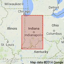
Lead Creek Limestone Member of Tradewater Formation in KY extended to IN and assigned to Mansfield Formation of Raccoon Creek Group. Reference section is designated in Spencer Co. Unit consists of limestone, shale, and siltstone. Includes Ferdinand and Fulda Beds, here reduced in rank. Age is Early Pennsylvanian.
Source: GNU records (USGS DDS-6; Reston GNULEX).
- Usage in publication:
-
- Lead Creek Member
- Modifications:
-
- Overview
- Areal extent
- AAPG geologic province:
-
- Illinois basin
Summary:
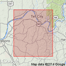
Lead Creek Member of Mansfield Formation is a marine unit composed of limestone that intergrades with shale and siltstone. It is traceable from its type area in the Tell City quadrangle (Kentucky) to southern Daviess County (Indiana). Farther north becomes discontinuous. Occurs 0 to 20 feet above the Mariah Hill coal and ranges up to about 25 feet thick. One or more limestone beds are separated by or grade laterally to calcareous, burrowed siltstone and dark gray to black shale containing marine fossils.
Source: GNU records (USGS DDS-6; Reston GNULEX).
For more information, please contact Nancy Stamm, Geologic Names Committee Secretary.
Asterisk (*) indicates published by U.S. Geological Survey authors.
"No current usage" (†) implies that a name has been abandoned or has fallen into disuse. Former usage and, if known, replacement name given in parentheses ( ).
Slash (/) indicates name conflicts with nomenclatural guidelines (CSN, 1933; ACSN, 1961, 1970; NACSN, 1983, 2005, 2021). May be explained within brackets ([ ]).