

- Usage in publication:
-
- Laredo formation*
- Modifications:
-
- Original reference
- Dominant lithology:
-
- Sandstone
- Marl
- Clay
- Limestone
- AAPG geologic province:
-
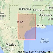
- Gulf Coast basin
Summary:
Pg. 297-298. Laredo formation of Claiborne group. Proposed for part of measured section of Claiborne group, that in the report on "Geology and ground-water resources of Webb County, Texas," by Lonsdale and Day (1937), is included under name Cook Mountain formation, and for all beds of equivalent age in Rio Grande embayment. Overlies Selman formation; underlies Yegua formation. Beds include both soft and indurated, glauconitic sandstone, glauconitic marl and clay, and thin limestones, commonly concretionary. In Laredo district, sands and sandstones make up more than 50 percent of formation; farther north, upper third of formation includes more clay than sandstone. Thickness near Laredo about 630 feet. Age is middle Eocene.
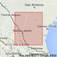
Area in which name is to apply extends from Frio, McMullen, and Live Oak Cos., southern TX, into northern Mexico.
Source: US geologic names lexicon (USGS Bull. 1200, p. 2107-2108).
- Usage in publication:
-
- Laredo Formation*
- Modifications:
-
- Areal extent
- AAPG geologic province:
-
- Gulf Coast basin
Summary:
Pg. D2, D4 (table 1), D21-D22. Laredo Formation of Claiborne Group. Replaces Cook Mountain Formation (geographically restricted) in the Rio Grande embayment south of Frio River, southern Texas. Is equivalent to Sparta Sand and Cook Mountain Formation of Texas Coastal Plain north of Frio River. Age is middle Eocene.
Source: Publication; Changes in stratigraphic nomenclature, 1968 (USGS Bull. 1294-A, p. A11).

- Usage in publication:
-
- Laredo Formation
- Modifications:
-
- Mapped 1:250k
- Dominant lithology:
-
- Sandstone
- Clay
- AAPG geologic province:
-
- Gulf Coast basin
Summary:
Laredo Formation. Sandstone and clay; thick sandstone members in upper and lower part, very fine- to fine-grained, in part glauconitic, ferruginous, dominantly red and brown; clay in middle, weathers orange-yellow. Thickness 600 to 700 feet. Correlative with Sparta Sand and Cook Mountain Formation mapped northeast of Frio River. Lies above El Pico Clay and below Yegua Formation. Age is Eocene.
[Mapped southwest of Frio River in Frio, Zavala, Dimmit, La Salle, and Webb Cos., southwestern TX.]
Source: Publication.
For more information, please contact Nancy Stamm, Geologic Names Committee Secretary.
Asterisk (*) indicates published by U.S. Geological Survey authors.
"No current usage" (†) implies that a name has been abandoned or has fallen into disuse. Former usage and, if known, replacement name given in parentheses ( ).
Slash (/) indicates name conflicts with nomenclatural guidelines (CSN, 1933; ACSN, 1961, 1970; NACSN, 1983, 2005, 2021). May be explained within brackets ([ ]).