The National Geologic Map Database is migrating to a new infrastructure. We apologize for any service disruptions during this process.
|
|---|


- Usage in publication:
-
- Lapoint horizon
- Modifications:
-
- Original reference
- Dominant lithology:
-
- Sandstone
- Clay
- Conglomerate
- AAPG geologic province:
-
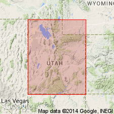
- Uinta basin
Summary:
Pg. 357-359. Lapoint horizon in Duchesne River formation. Present in Uinta basin, eastern Utah. Age is Oligocene. See under Randlett horizon.
Source: US geologic names lexicon (USGS Bull. 896, p. 1149, 1770).
- Usage in publication:
-
- Lapoint Member
- Modifications:
-
- Reference
- Dominant lithology:
-
- Claystone
- Sandstone
- Siltstone
- Conglomerate
- AAPG geologic province:
-
- Uinta basin
Summary:
Formerly called Lapoint horizon. Name applied to one of four members of Duchesne River Formation. Is slightly restricted unit equivalent to nearly all the original Lapoint. Reference section designated as measured section in north central portion of sec 1, T5S, R19E, north of Hwy 245 north to short spur in east-central part of sec 25, T4S, R19E, Uintah Co, UT in the Uinta basin, where section 401+ ft thick present above Dry Gulch Creek Member (new) and beneath Starr Flat Member (new). Composed of olive, green-gray, dark gray, very thin to thin bedded, nodular, poorly sorted, horizontally stratified, laminated claystone; light gray, light brown, gray orange to red brown, thin-bedded, slabby, horizontally stratified, poorly sorted, medium-grained, to thick-bedded, blocky, poorly sorted, coarse-grained sandstone; gray-red to red-brown, thin-bedded, nodular, horizontally stratified, poorly sorted siltstone; and gray-orange, very thick bedded, massive, poorly sorted pebble conglomerate. Lower contact with Dry Creek Gulch placed at base of lowest extensive bentonite. Upper contact placed at base of lowest red-brown sandstone or conglomerate. Abundant vertebrate fossils (reptiles, mammals) listed. Duchesnean age. Latest Eocene. Cross sections.
Source: GNU records (USGS DDS-6; Denver GNULEX).
- Usage in publication:
-
- Lapoint Member*
- Modifications:
-
- Areal extent
- Geochronologic dating
- AAPG geologic province:
-
- Uinta basin
Summary:
Adopted as one of four members of Duchesne River Formation. Occurs along structural axis of Uinta basin between Asphalt Ridge and Rock Creek, Uintah and Duchesne Cos, UT (geologic map). Basal beds interfinger with Dry Gulch Member. Interfingers with overlying Starr Flat Member. An age of about 33 Ma indicated for basal part of member (west) to 35 and 37 Ma for basal part (east). Other isotopic ages obtained range from 36.9 +/-1.8 to 28.7 +/-2.0 Ma on zircon. Oligocene age.
Source: GNU records (USGS DDS-6; Denver GNULEX).
For more information, please contact Nancy Stamm, Geologic Names Committee Secretary.
Asterisk (*) indicates published by U.S. Geological Survey authors.
"No current usage" (†) implies that a name has been abandoned or has fallen into disuse. Former usage and, if known, replacement name given in parentheses ( ).
Slash (/) indicates name conflicts with nomenclatural guidelines (CSN, 1933; ACSN, 1961, 1970; NACSN, 1983, 2005, 2021). May be explained within brackets ([ ]).