The National Geologic Map Database is migrating to a new infrastructure. We apologize for any service disruptions during this process.
|
|---|


- Usage in publication:
-
- Lake Crockett formation
- Modifications:
-
- Named
- Dominant lithology:
-
- Sand
- Shale
- AAPG geologic province:
-
- South Oklahoma folded belt
- Ouachita folded belt
- East Texas basin
Summary:
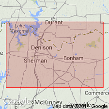
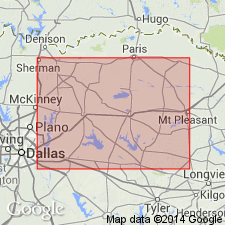
Named as formation in the upper part of the Eagle Ford group for exposures in the ravine below the spillway of Lake Crockett, Fannin Co, TX in the Ouachita tectonic belt province. Measured section described below spillway. Occurs in outcrop near Sherman, Grayson Co, TX in the South Oklahoma folded belt province and in the subsurface in the East Texas basin. Formerly called the Fish Bed conglomerate (Taff, 1893) near the top of Eagle Ford group in Grayson and Fannin Cos, TX; the Blossom sand member of the Eagle Ford formation at Sherman, TX (Gordon, 1911), and the sub-Clarksville formation in the subsurface of the East Texas basin (Herald, 1951). Consists of two members: 1) a lower Lake Crockett sand member of gray, fine-grained, friable sandstone, weathering yellowish brown to maroon with hematite, at least 5 ft thick, overlain by 0.5 ft of gray to reddish-brown, sandy, phosphatic conglomerate that weathers light gray, containing chert pebbles, petrified wood, and rare molluscan and fish remains, 2) an upper Lake Crockett shale member of soft, gray, thin-bedded to laminated, alternating sands, silts, clays, and gypsiferous shales; argillaceous beds predominant; 20-30 ft thick. Overlies shale of the Eagle Ford group with transitional contact. Underlies Ector formation [Late Cretaceous].
Source: GNU records (USGS DDS-6; Denver GNULEX).
- Usage in publication:
-
- Lake Crockett Formation†
- Modifications:
-
- Abandoned
Summary:
Abandoned because of homonymous nomenclature unsuitable for the rock-stratigraphic character of the units as they occur in the Ouachita tectonic belt and South Oklahoma folded belt provinces. No replacement name proposed. Two component members of the formation also abandoned. Lake Crockett Sand Member is abandoned and replaced by the Bells Sandstone Member. Lake Crockett Shale Member is abandoned and replaced by the Maribel Shale Member.
Source: GNU records (USGS DDS-6; Denver GNULEX).
For more information, please contact Nancy Stamm, Geologic Names Committee Secretary.
Asterisk (*) indicates published by U.S. Geological Survey authors.
"No current usage" (†) implies that a name has been abandoned or has fallen into disuse. Former usage and, if known, replacement name given in parentheses ( ).
Slash (/) indicates name conflicts with nomenclatural guidelines (CSN, 1933; ACSN, 1961, 1970; NACSN, 1983, 2005, 2021). May be explained within brackets ([ ]).