

- Usage in publication:
-
- Lagunita formation
- Modifications:
-
- Original reference
- Dominant lithology:
-
- Limestone
- AAPG geologic province:
-
- Estancia basin
Summary:
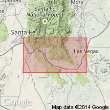
Pg. 307-308. Lagunita formation of San Andres group. Contorted brecciated vuggy limestone. Has overall appearance similar to travertine. Fragments in formation are pink, red, gray, dark blue, green, and yellow. Commonly occur in pebble and cobble size ranges. Thickness ranges from a few inches to about 90 feet, but generally does not exceed 20 feet. Represents middle unit of group; underlies Bernal formation; overlies Glorieta formation. Typical beachrock, altered slightly by later solution and recrystallization.
Type locality not stated. Named from village of Lagunita, near Santa Fe RR between Las Vegas and Santa Fe (approx. Lat. 35 deg. 23 min. N., Long. 105 deg. 14 min. W.). Better and more accessible exposure at northwest corner of base of Chapelle Hill, on Santa Fe RR, between villages of Chapelle and Bernal (approx. in sec. 36, T. 14 N., R. 15 E.), north-central NM.
Source: US geologic names lexicon (USGS Bull. 1200, p. 2073-2074).
For more information, please contact Nancy Stamm, Geologic Names Committee Secretary.
Asterisk (*) indicates published by U.S. Geological Survey authors.
"No current usage" (†) implies that a name has been abandoned or has fallen into disuse. Former usage and, if known, replacement name given in parentheses ( ).
Slash (/) indicates name conflicts with nomenclatural guidelines (CSN, 1933; ACSN, 1961, 1970; NACSN, 1983, 2005, 2021). May be explained within brackets ([ ]).