The National Geologic Map Database is migrating to a new infrastructure. We apologize for any service disruptions during this process.
|
|---|


- Usage in publication:
-
- Ladrones Limestone*
- Modifications:
-
- Named
- Biostratigraphic dating
- Dominant lithology:
-
- Limestone
- Dolomite
- AAPG geologic province:
-
- Alaska Southeastern region
Summary:
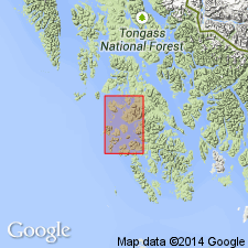
Named for exposures at type locality on Ladrones Islands, between Bucareli and Trocadero Bays [55 deg 20'N, 133 deg 5'W] AK. Composed of sublithographic, massive, fossiliferous thick-bedded limestone with minor finely crystalline dolomite and dolomitic limestone. Is at least 1000 ft thick. Conformably overlies Peratrovich Formation (new). Upper contact not exposed. Age is considered to range from Early Pennsylvanian to early Middle Pennsylvanian based on presence of small fusulinids (R.C. Douglass, oral commun., 1968) and a preliminary study by A.K. Armstrong of its endothyroid foraminifers, corals, and brachiopods.
Source: GNU records (USGS DDS-6; Menlo GNULEX).
For more information, please contact Nancy Stamm, Geologic Names Committee Secretary.
Asterisk (*) indicates published by U.S. Geological Survey authors.
"No current usage" (†) implies that a name has been abandoned or has fallen into disuse. Former usage and, if known, replacement name given in parentheses ( ).
Slash (/) indicates name conflicts with nomenclatural guidelines (CSN, 1933; ACSN, 1961, 1970; NACSN, 1983, 2005, 2021). May be explained within brackets ([ ]).