The National Geologic Map Database is migrating to a new infrastructure. We apologize for any service disruptions during this process.
|
|---|


- Usage in publication:
-
- Ladd formation
- Modifications:
-
- First used
- Biostratigraphic dating
- Dominant lithology:
-
- Shale
- Siltstone
- Conglomerate
- Sandstone
- AAPG geologic province:
-
- Peninsular Ranges province
Summary:
Pg. 380. Ladd formation. Briefly described in "Generalized section of formations in the Santa Ana Mountains, California." Comprises two members, both new (ascending): Baker member, conglomerate grading upward into sandstone, fossiliferous at top, about 200 feet thick; Holz member, sandy shale or siltstone with interbedded arkosic sandstone, fossiliferous in upper half, about 1,500 feet thick. Overlies Cretaceous(?) Trabuco formation; unconformably underlies Williams formation (new). Age is Late Cretaceous based on molluscan fossils described in report.
Source: Publication; GNU records (USGS DDS-6; Menlo GNULEX); US geologic names lexicon (USGS Bull. 1200, p. 2068).
- Usage in publication:
-
- Ladd formation
- Modifications:
-
- Named
- Biostratigraphic dating
- Dominant lithology:
-
- Conglomerate
- Sandstone
- Shale
- AAPG geologic province:
-
- Peninsular Ranges province
Summary:
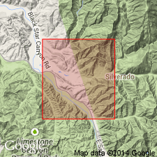
Type locality designated in region immediately west of mouth of Ladd Canyon, tributary of Silverado Canyon [33 deg 44'51"N, 117 deg 38'23"W, El Toro 7.5' quad, Orange Co, CA]. Ladd formation includes Cretaceous rocks of Santa Ana Mountains lying stratigraphically above Trabuco conglomerate and below Williams formation. Maximum measured thickness is 1700 ft. Divided into (ascending); Baker Canyon member and Holz shale member. [Note that Baker Canyon member was named "Baker member" by Popenoe (1937) and "Baker conglomerate" by Popenoe (1941)]. Age is Late Cretaceous based on molluscan fossils listed and described in report.
Source: GNU records (USGS DDS-6; Menlo GNULEX).
- Usage in publication:
-
- Ladd formation*
- Modifications:
-
- Adopted
- AAPG geologic province:
-
- Peninsular Ranges province
Summary:
Stratigraphic chart of northwestern Santa Ana Mountains shows Holz shale member of Ladd formation unconformably underlies Silverado formation (new). Age given as Late Cretaceous.
Source: GNU records (USGS DDS-6; Menlo GNULEX).
For more information, please contact Nancy Stamm, Geologic Names Committee Secretary.
Asterisk (*) indicates published by U.S. Geological Survey authors.
"No current usage" (†) implies that a name has been abandoned or has fallen into disuse. Former usage and, if known, replacement name given in parentheses ( ).
Slash (/) indicates name conflicts with nomenclatural guidelines (CSN, 1933; ACSN, 1961, 1970; NACSN, 1983, 2005, 2021). May be explained within brackets ([ ]).