The National Geologic Map Database is migrating to a new infrastructure. We apologize for any service disruptions during this process.
|
|---|


- Usage in publication:
-
- La Sierra tonalite*
- Modifications:
-
- Named
- Dominant lithology:
-
- Tonalite
- AAPG geologic province:
-
- Peninsular Ranges province
Summary:
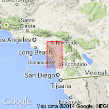
Named for several small bodies in hills of La Sierra, north and northeast of Corona, Riverside Co, CA. [Name first used by Larsen and Keevil (1947) in report on batholith of southern CA]. Total area is about 3 sq mi plus more covered by alluvium. Occurs in area of deep weathering and erosion. Tonalite is little darker gray than associated granodiorites. Intruded by Woodson Mountain granodiorite. Map legend shows age as Cretaceous.
Source: GNU records (USGS DDS-6; Menlo GNULEX).
For more information, please contact Nancy Stamm, Geologic Names Committee Secretary.
Asterisk (*) indicates published by U.S. Geological Survey authors.
"No current usage" (†) implies that a name has been abandoned or has fallen into disuse. Former usage and, if known, replacement name given in parentheses ( ).
Slash (/) indicates name conflicts with nomenclatural guidelines (CSN, 1933; ACSN, 1961, 1970; NACSN, 1983, 2005, 2021). May be explained within brackets ([ ]).