

- Usage in publication:
-
- La Plata sandstone
- Modifications:
-
- Original reference
- AAPG geologic province:
-
- Paradox basin
- San Juan basin
Summary:
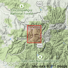
Pg. 759; named by Whitman Cross. La Plata sandstone. Lying directly on the Trias (mostly red sandstones) in Telluride quadrangle, Colorado, is lower member of Jura. It consists of friable medium-grained white sandstone, of massive appearance, which has a thickness of 50 to 100 feet. It has been called La Plata sandstone by Whitman Cross, owing to its extensive development in La Plata Mountains, to south.
Geologic map accompanying report, the areal geology of which is by Whitman Cross. La Plata sandstone. Two white sandstone layers with dark limestone between them. Underlies Gunnison formation and overlies Dolores formation.
Source: US geologic names lexicon (USGS Bull. 896, p. 1149).
- Usage in publication:
-
- La Plata member*
- Modifications:
-
- Revised
- AAPG geologic province:
-
- San Juan basin
Summary:
[Credited to Whitman Cross.] It is proposed to name lower member of Gunnison formation after La Plata Mountains, on account of its prominent and characteristic exposures in peaks and on slopes of that mountain group. From dominant development of white sandstone in Telluride ond other quadrangles, it is there quite appropriate to call this formation La Plata sandstone, but it is known that the thin limestone of Telluride area represents a much more extensive series of shales, etc., in some other regions. In this quadrangle La Plata formation consists of 2 massive sandstone members separated by a thin dense bluish or almost black limestone 6 to 16 feet thick. Total thickness here is seldom more than 100 feet. The sandstones here are very light gray or white, but in many places, especially to south and west, a distinct or even brilliant coloring in varying shades of red or orange has been observed in the lower sandstone. But the contrast with the bright-red strata of underlying Dolores formation is very striking. The 2 sandstone members are usually of similar character, but in this quadrangle the upper one is sometimes thin bedded and shaly and much less prominent than the lower. The upper sandstone layer is succeeded by a highly colored shale, taken as lowest stratum of McElmo formation. The McElmo is Gunnison formation restricted of Purington. Type Gunnison includes McElmo and La Plata.
Source: US geologic names lexicon (USGS Bull. 896, p. 1149).
- Usage in publication:
-
- La Plata group*
- Modifications:
-
- Not used
- AAPG geologic province:
-
- San Juan basin
Summary:
Divided in San Juan basin into (ascending): Wingate sandstone [would be assigned to Entrada sandstone by most mappers in 1986], Todilto limestone (first used), and Navajo sandstone [would be assigned to upper part of Wanakah by most mappers in 1986]. Wingate is a 30-450 ft thick, massive, cross-bedded red sandstone that forms vertical cliffs, alcoves, and natural bridges. Navajo is a 400-1,000 ft thick, red, massive, cross-bedded sandstone. Unconformably overlies Chinle formation (first description); underlies McElmo formation of Jurassic age. Geologic map. Generalized columnar section.
Source: GNU records (USGS DDS-6; Denver GNULEX).

- Usage in publication:
-
- La Plata sandstone†
- Modifications:
-
- Abandoned
- AAPG geologic province:
-
- Paradox basin
- San Juan basin
Summary:
Upper Jurassic †La Plata sandstone of southwestern Colorado and southeastern Utah is abandoned. See explanation under †McElmo formation, for reasons for abandonment. Also see USGS Prof. Paper 183, 1936, by A.A. Baker, C.H. Dane, and J.B. Reeside, Jr., for details regarding the units into which the La Plata sandstone of different authors, in different areas, is now divided.
Source: US geologic names lexicon (USGS Bull. 896, p. 1149).
- Usage in publication:
-
- La Plata sandstone*
- Modifications:
-
- Not used
- AAPG geologic province:
-
- Paradox basin
- San Juan basin
Summary:
Beds formerly assigned to La Plata sandstone are reassigned to other named units. The basal sandstone is Entrada sandstone. The discontinuous, thin-bedded bituminous limestone is Pony Express limestone member (revised) of Morrison formation. The cherty marls are Wanakah marl member (revised) of Morrison formation, and the massive cross-bedded sandstone is named Junction Creek sandstone member of Morrison formation.
Source: GNU records (USGS DDS-6; Denver GNULEX).
For more information, please contact Nancy Stamm, Geologic Names Committee Secretary.
Asterisk (*) indicates published by U.S. Geological Survey authors.
"No current usage" (†) implies that a name has been abandoned or has fallen into disuse. Former usage and, if known, replacement name given in parentheses ( ).
Slash (/) indicates name conflicts with nomenclatural guidelines (CSN, 1933; ACSN, 1961, 1970; NACSN, 1983, 2005, 2021). May be explained within brackets ([ ]).