

- Usage in publication:
-
- Kuzitrin series*
- Modifications:
-
- Named
- Dominant lithology:
-
- Schist
- Slate
- AAPG geologic province:
-
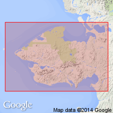
- Seward Peninsula province
- Alaska West-Central region
Summary:
Named from Kuzitrin River, Seward Peninsula, AK, along whose lower course, unit is well exposed. Typically exposed in Kigluaik Mountains, near their northern limit, in belt which runs parallel to axis of range and cut by tributaries of Kruzgamepa River. Composed of well-jointed graphitic quartz-schist, intercalated graphitic slates, and calcareous, amphibole, and chloritic schists. Estimated thickness is between 2000 and 3000 ft. Overlies Kigluaik series (new). Underlies Nome series (new). Map legend shows age is Paleozoic or older.
Source: GNU records (USGS DDS-6; Menlo GNULEX).
- Usage in publication:
-
- Kuzitrin formation*
- Modifications:
-
- Revised
- Age modified
- AAPG geologic province:
-
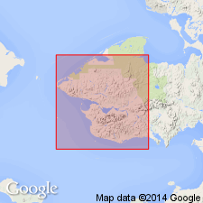
- Seward Peninsula province
- Alaska West-Central region
Summary:
Kuzitrin series of Brooks and others (1901) revised as Kuzitrin formation. Type locality [designated] along Kuzitrin River. Consists for the most part of graphitic quartzites and siliceous schists. May exist as undifferentiated member of Nome Group west of Grand Central River. Stratigraphic chart shows Kuzitrin as basal pre-Silurian(?) unit in Nome Group. Overlies Kigluaik group. No direct evidence for its age, but Kuzitrin may belong near base of Ordovician though probably could be either Cambrian or Algonkian.
Source: GNU records (USGS DDS-6; Menlo GNULEX).
- Usage in publication:
-
- Kuzitrin group*
- Modifications:
-
- Revised
- AAPG geologic province:
-
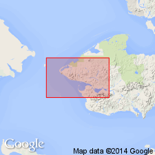
- Seward Peninsula province
- Alaska West-Central region
Summary:
Kuzitrin group of graphitic quartzite apparently conformably overlies Kigluaik group. Underlies Nome group. Provisional correlation table shows age may be Cambrian or pre-Cambrian.
Source: GNU records (USGS DDS-6; Menlo GNULEX).
- Usage in publication:
-
- Kuzitrin Series†
- Modifications:
-
- Abandoned
- AAPG geologic province:
-
- Seward Peninsula province
- Alaska West-Central region
Summary:
Kuzitrin Series name abandoned. Rocks in part included in Tigaraha Schist of Kigluaik Group and in part in informal "slate of the York region" (term first used by Knopf, 1908).
Source: GNU records (USGS DDS-6; Menlo GNULEX).
For more information, please contact Nancy Stamm, Geologic Names Committee Secretary.
Asterisk (*) indicates published by U.S. Geological Survey authors.
"No current usage" (†) implies that a name has been abandoned or has fallen into disuse. Former usage and, if known, replacement name given in parentheses ( ).
Slash (/) indicates name conflicts with nomenclatural guidelines (CSN, 1933; ACSN, 1961, 1970; NACSN, 1983, 2005, 2021). May be explained within brackets ([ ]).