

- Usage in publication:
-
- Kuskulana Pass Formation*
- Modifications:
-
- Named
- Dominant lithology:
-
- Sandstone
- Siltstone
- AAPG geologic province:
-
- Alaska Southern region
Summary:
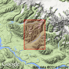
Named for exposures near Kuskulana Pass. Type section designated as exposures extending south from NE 1/4 SE 1/4 SW 1/4 sec.32 T3S R10E to NE 1/4 SW 1/4 NW 1/4 sec.5 T4S R10E, upper drainage basin of Trail and Slatka Creeks near Kuskalana Pass, McCarthy C-8 quad, Wrangell Mountains, AK. Consists of dark-greenish gray or medium-gray (weathering brown) sandstone, siltstone and minor shale. Thickness is 300 m. Shallow marine deposits are thin-bedded, fine- and very fine-grained, and meagerly fossiliferous. Gradationally overlies Berg Creek Formation; disconformably, or with slight angular unconformity, underlies Kennicott Formation. Is Early Cretaceous (Hauterivian and Barremian) age.
Source: GNU records (USGS DDS-6; Menlo GNULEX).
For more information, please contact Nancy Stamm, Geologic Names Committee Secretary.
Asterisk (*) indicates published by U.S. Geological Survey authors.
"No current usage" (†) implies that a name has been abandoned or has fallen into disuse. Former usage and, if known, replacement name given in parentheses ( ).
Slash (/) indicates name conflicts with nomenclatural guidelines (CSN, 1933; ACSN, 1961, 1970; NACSN, 1983, 2005, 2021). May be explained within brackets ([ ]).