

- Usage in publication:
-
- Kuna Formation*
- Modifications:
-
- Named
- Biostratigraphic dating
- Dominant lithology:
-
- Shale
- Chert
- Limestone
- Dolomite
- AAPG geologic province:
-
- Alaska Northern region
Summary:
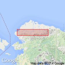
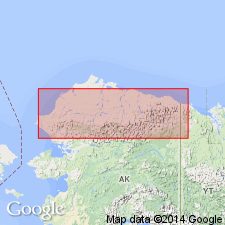
Named as formation in Lisburne Group for exposures in Kuna River drainage in western Endicott Mountains. Type section designated in valley of upper tributary of Kuna River, SW/4 sec.21 T34N R5E, western Howard Pass (1:250,000) quad, northern AK. Five reference sections also designated. Also occurs in DeLong Mountains. Rocks previously informally designated as "dark colored facies" of Lisburne Group. Consists dominantly of black carbonaceous shale, black chert, fine-grained limestone and dolomite. Thickness ranges from 45 to 100 m. In Endicott Mountains intertongues with Wachsmuth Limestone and Alapah Limestone (both of Lisburne Group). Gradationally overlies Kayak Shale of Endicott Group in western Endicott Mountains. Gradationally and locally disconformably underlies Siksikpuk Formation of Etivluk Group (new). Age is Early Mississippian to Early or Middle Pennsylvanian on basis of paleontologic evidence.
Source: GNU records (USGS DDS-6; Menlo GNULEX).
- Usage in publication:
-
- Kuna Formation*
- Modifications:
-
- Age modified
- Biostratigraphic dating
- AAPG geologic province:
-
- Alaska Northern region
Summary:
Age in south-central Brooks Range is considered to be Late Mississippian only based on revised megafossil zonations. Assemblages (goniatites, mollusks, brachiopods, and corals) range from Meramecian to Chesterian in age.
Source: GNU records (USGS DDS-6; Menlo GNULEX).
- Usage in publication:
-
- Kuna Formation*
- Modifications:
-
- Areal extent
- AAPG geologic province:
-
- Alaska Northern region
Summary:
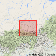
Unit geographically restricted from Chandler Lake quad; its strata are reassigned to the (undivided) Alapah and Wachsmuth Limestones and (undivided) Lisburne Group.
Source: GNU records (USGS DDS-6; Menlo GNULEX).
For more information, please contact Nancy Stamm, Geologic Names Committee Secretary.
Asterisk (*) indicates published by U.S. Geological Survey authors.
"No current usage" (†) implies that a name has been abandoned or has fallen into disuse. Former usage and, if known, replacement name given in parentheses ( ).
Slash (/) indicates name conflicts with nomenclatural guidelines (CSN, 1933; ACSN, 1961, 1970; NACSN, 1983, 2005, 2021). May be explained within brackets ([ ]).