The National Geologic Map Database is migrating to a new infrastructure. We apologize for any service disruptions during this process.
|
|---|


- Usage in publication:
-
- Kugururok formation*
- Modifications:
-
- Named
- Biostratigraphic dating
- Dominant lithology:
-
- Shale
- Sandstone
- Limestone
- Dolomite
- AAPG geologic province:
-
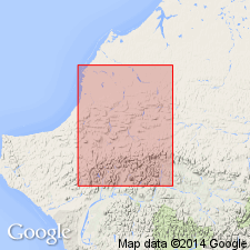
- Alaska Northern region
Summary:
Named from Kugururok River. Type section designated on north side of Mont Bastille, central DeLong Mountains, northern AK. At type, three informal lithologic members are (ascending): lower dominantly clastic unit (shale with interbedded sandstone, granule conglomerate, siltstone and limestone), middle calcarenite unit (with some conglomeratic limestone, sparse chert lenses and dolomitic(?) sandstone), and upper light-colored, laminated to cross-bedded dolomite unit. Thickness at type is 1370 ft, elsewhere over 2000 ft. Occurs in thrust plate and overlies Mississippian(?) carbonate rocks. At type underlies dark shales of probable Jurassic or Early Cretaceous age. Age is Late Devonian (Frasnian and Famennian) based on paleontological evidence.
Source: GNU records (USGS DDS-6; Menlo GNULEX).

- Usage in publication:
-
- Kugururok Formation*
- Modifications:
-
- Revised
- AAPG geologic province:
-
- Alaska Northern region
Summary:
Kugururok Formation assigned to Baird Group (new). Projects into part of Skagit Limestone of Baird Group in eastern DeLong Mountains.
Source: GNU records (USGS DDS-6; Menlo GNULEX).
For more information, please contact Nancy Stamm, Geologic Names Committee Secretary.
Asterisk (*) indicates published by U.S. Geological Survey authors.
"No current usage" (†) implies that a name has been abandoned or has fallen into disuse. Former usage and, if known, replacement name given in parentheses ( ).
Slash (/) indicates name conflicts with nomenclatural guidelines (CSN, 1933; ACSN, 1961, 1970; NACSN, 1983, 2005, 2021). May be explained within brackets ([ ]).