The National Geologic Map Database is migrating to a new infrastructure. We apologize for any service disruptions during this process.
|
|---|


- Usage in publication:
-
- Kriley formation
- Modifications:
-
- Named
- Dominant lithology:
-
- Conglomerate
- AAPG geologic province:
-
- Idaho Mountains province
Summary:
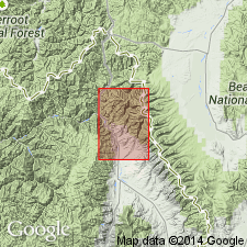
Named probably for Kriley Creek, Ts23 and 24N, Rs21 and 22E, Lemhi Co, ID in Idaho Mountains province. No type locality designated. Is exposed along the Salmon River. Two exposures mapped on east side of river and two on west side of river. Geologic map; cross sections. Is chiefly a thick (800+ ft) conglomerate. Lower part is coarsely textured, has boulders up to a ft in diameter cemented in a sandy and silty matrix. The well water-worn boulders were derived from the Lemhi Quartzite. Some of the conglomerate derived from granitic rocks. Basal unit is overlain by light-colored, well stratified sandy shale and sandstone. Is unconformable on Lemhi. Unconformably under Challis Volcanics or Geertson Formation. No fossils found. Considered therefore younger than Idaho batholith and older than Challis. May be correlated with the Beaverhead. Assigned to the Paleocene?.
Source: GNU records (USGS DDS-6; Denver GNULEX).
For more information, please contact Nancy Stamm, Geologic Names Committee Secretary.
Asterisk (*) indicates published by U.S. Geological Survey authors.
"No current usage" (†) implies that a name has been abandoned or has fallen into disuse. Former usage and, if known, replacement name given in parentheses ( ).
Slash (/) indicates name conflicts with nomenclatural guidelines (CSN, 1933; ACSN, 1961, 1970; NACSN, 1983, 2005, 2021). May be explained within brackets ([ ]).