The National Geologic Map Database is migrating to a new infrastructure. We apologize for any service disruptions during this process.
|
|---|


- Usage in publication:
-
- Kress Member
- Modifications:
-
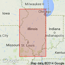
- Areal extent
- Dominant lithology:
-
- Conglomerate
- Shale
- AAPG geologic province:
-
- Wisconsin arch
Summary:
Pg. 13, 35, 45. Kress Member of St. Peter Sandstone. In many places is a coarse basal conglomerate consisting largely of rubble-like deposit of irregular blocks of chert with a matrix of clay, sand, or chert. In many areas a red argillaceous unit is present at base of St. Peter Formation. This unit reaches maximum thickness of 170 feet in well at Rochelle, Ogle County, northern Illinois. One or more layers of bentonite occur in red clay or white sandstone just above base of formation in Ogle County. Elsewhere the Kress consists of well-bedded deposits of red and green shales, generally containing thin beds of sandstone. Clay and shale phase of the Kress is locally exposed in Split Rock section, particularly along Pecumsaugan Creek, where it is 10 feet thick. Irregular in distribution; appears to be present at least locally throughout area of St. Peter Sandstone but is more common and thicker in some areas than others. Appears to be thickest, locally exceeding 100 feet, immediately north of north-facing pre-St. Peter escarpment of Prairie du Chien dolomites that extends from central part of Chicago slightly north of west across northern Illinois. Underlies Tonti Member (new). Kress Member is the basal shaly and conglomeratic zone of St. Peter Sandstone referred to in many Illinois, Iowa, Minnesota, Missouri, and Wisconsin reports. Name credited to T.C. Buschbach (in press). Age is Middle Ordovician (Champlainian).
Source: US geologic names lexicon (USGS Bull. 1350, p. 403-404).
- Usage in publication:
-
- Kress Member
- Modifications:
-
- Principal reference
- Dominant lithology:
-
- Conglomerate
- Shale
- AAPG geologic province:
-
- Wisconsin arch
Summary:
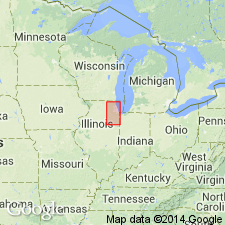
Pg. 50 (fig. 17), 51-52. Kress Member of St. Peter Sandstone. Formal proposal of name. Type well designated. Basal member of St. Peter. Underlies unnamed member of St. Peter in area of this report [northeastern Illinois]. Age is Middle Ordovician (Champlainian).
Type section (subsurface): depth-interval 940 to 1,004 ft, Elgin, Joliet and Eastern RR No. 1 (reference well 48) cable tool well, in NW/4 NE/4 SE/4 sec. 32, T. 40 N., R. 9 E., DuPage Co., northern IL. Named from Kress Creek, northwest of West Chicago, DuPage Co., IL. The creek flows southward in secs. 6, 7, and 8, T. 39 N., R. 9 E. The headwaters of the creek are about 1.5 mi southwest of type well.
Source: US geologic names lexicon (USGS Bull. 1350, p. 403-404).
- Usage in publication:
-
- Kress Member
- Modifications:
-
- Not used
- AAPG geologic province:
-
- Wisconsin arch
Summary:
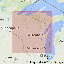
Name Readstown Member (new) used in Wisconsin in preference to name Kress.
Source: US geologic names lexicon (USGS Bull. 1350, p. 403-404).

- Usage in publication:
-
- Kress Member*
- Modifications:
-
- Mapped 1:100k
- AAPG geologic province:
-
- Illinois basin
- Ozark uplift
Summary:
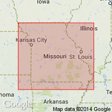
Kress Member of St. Peter Sandstone. Present in St. Louis area, in Missouri and Illinois. Consists of strongly weathered and reworked green shale, sandstone, and chert detritus. Age is Middle Ordovician (Mohawkian).
Source: Modified from GNU records (USGS DDS-6; Reston GNULEX).
- Usage in publication:
-
- Kress Member
- Modifications:
-
- Overview
- AAPG geologic province:
-
- Ozark uplift
Summary:
Pg. 157. Kress Member of St. Peter Sandstone. The Kress is the residual section on top of the Ibexian Series when it lies beneath Paleozoic strata. It, therefore, can probably be as young as early Pennsylvanian in some places, where the rest of the St. Peter Sandstone has been removed by erosion. Age is considered Ordovician to Pennsylvanian.
Source: Publication.
For more information, please contact Nancy Stamm, Geologic Names Committee Secretary.
Asterisk (*) indicates published by U.S. Geological Survey authors.
"No current usage" (†) implies that a name has been abandoned or has fallen into disuse. Former usage and, if known, replacement name given in parentheses ( ).
Slash (/) indicates name conflicts with nomenclatural guidelines (CSN, 1933; ACSN, 1961, 1970; NACSN, 1983, 2005, 2021). May be explained within brackets ([ ]).