The National Geologic Map Database is migrating to a new infrastructure. We apologize for any service disruptions during this process.
|
|---|


- Usage in publication:
-
- Kremmling Sandstone Member*
- Modifications:
-
- Named
- Dominant lithology:
-
- Siltstone
- Sandstone
- AAPG geologic province:
-
- North Park basin
Summary:
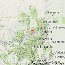
Named as a member in the middle part of Pierre Shale for exposures at Muddy Buttes about half a mile north of Kremmling, Grand Co, CO in North Park basin. Type locality is in SE1/4 NW1/4 sec 7, T1N, R80W. Is about 1,900 ft above base of Pierre. Lower part consists of shaly siltstone and upper part is flaggy very fine-grained sandstone. Ripple marks and worm trails are found along the bedding planes. Ranges from 20 to 70 ft thick; variation in thickness attributable to a gradational lower contact. Overlies and underlies unnamed parts of the Pierre. Is within the Range Zone of BACULITES PERPLEXUS. Assigned to late Campanian or is of Late Cretaceous age.
Source: GNU records (USGS DDS-6; Denver GNULEX).
For more information, please contact Nancy Stamm, Geologic Names Committee Secretary.
Asterisk (*) indicates published by U.S. Geological Survey authors.
"No current usage" (†) implies that a name has been abandoned or has fallen into disuse. Former usage and, if known, replacement name given in parentheses ( ).
Slash (/) indicates name conflicts with nomenclatural guidelines (CSN, 1933; ACSN, 1961, 1970; NACSN, 1983, 2005, 2021). May be explained within brackets ([ ]).