

- Usage in publication:
-
- Kongakut Formation*
- Modifications:
-
- Named
- Dominant lithology:
-
- Shale
- Siltstone
- Sandstone
- AAPG geologic province:
-
- Alaska Northern region
Summary:
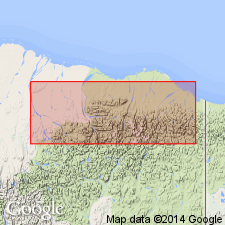
Named for exposures in upper Kongakut River area. Rocks formerly part of Okpikruak Formation. Kemik Sandstone Member of Okpikruak Formation reassigned to Kongakut Formation. Three informal and one named member are (ascending): clay shale, Kemik Sandstone, pebble shale, and siltstone members. Type section for Kongakut designated on north flank of Bathtub Ridge 15.8 km (9.2 mi) S 85 deg W of mouth of Cottonwood Creek, 69 deg 06'30"N, 142 deg 17'W, northeastern AK. Is dominantly shale and siltstone with minor sandstone. Is 2090 ft thick at type. Unconformably overlies Ivishak Formation of Sadlerochit Group; conformably underlies Bathtub Graywacke (new). Age is Early Cretaceous (Neocomanian) on basis of sparse megafauna in lower part of unit.
Source: GNU records (USGS DDS-6; Menlo GNULEX).
- Usage in publication:
-
- Kongakut Formation*
- Modifications:
-
- Areal extent
- Revised
- AAPG geologic province:
-
- Alaska Northern region
Summary:
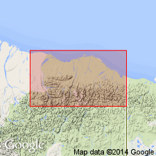
Unit geographically restricted from "...along the mountain front and coastal plain" in northeastern AK (area around Sadlerochit Mountains and extending to southwest approximately 40 mi to Echooka River). Rocks are reassigned to Kemik Sandstone (rank raised) and pebble shale unit. [As such, Kongakut Formation is only recognized at present in Bathtub Ridge area (type area).] Age remains Early Cretaceous.
Source: GNU records (USGS DDS-6; Menlo GNULEX).
For more information, please contact Nancy Stamm, Geologic Names Committee Secretary.
Asterisk (*) indicates published by U.S. Geological Survey authors.
"No current usage" (†) implies that a name has been abandoned or has fallen into disuse. Former usage and, if known, replacement name given in parentheses ( ).
Slash (/) indicates name conflicts with nomenclatural guidelines (CSN, 1933; ACSN, 1961, 1970; NACSN, 1983, 2005, 2021). May be explained within brackets ([ ]).