The National Geologic Map Database is migrating to a new infrastructure. We apologize for any service disruptions during this process.
|
|---|


- Usage in publication:
-
- Koloa series
- Modifications:
-
- First used
- AAPG geologic province:
-
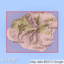
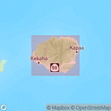
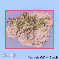
- Kauai
Hinds, N.E.A., 1930, Geology of Kauai and Niihau: Bernice P. Bishop Museum Bulletin, no. 71, 103 p.
Summary:
Late Koloa volcanic episode produced lavas and pyroclastics referred to as "Koloa series".
Source: GNU records (USGS DDS-6; Menlo GNULEX).
- Usage in publication:
-
- Koloa volcanic series*
- Modifications:
-
- Named
- Dominant lithology:
-
- Basalt
- AAPG geologic province:
-
- Kauai
Summary:
Koloa series of Hinds [1930] is named Koloa volcanic series which form broad plain between Koloa and Kapaa, Island of Kauai. Composed of olivine basalts and ultrabasic rocks carrying nepheline and melilite. Divided into older rocks of Pleistocene age and younger rocks of Recent age on fig. map. Overlies with erosional unconformity Waimea volcanic and Haupu volcanic series (new). Underlies Pleistocene alluvium and lithified calcareous dunes.
Source: GNU records (USGS DDS-6; Menlo GNULEX).
- Usage in publication:
-
- Koloa volcanic series*
- Modifications:
-
- Age modified
- AAPG geologic province:
-
- Kauai
Summary:
Lavas include olivine basalt, picrite-basalt (mimosite), and nepheline basalt. Assigned Pleistocene age on fig. map
Source: GNU records (USGS DDS-6; Menlo GNULEX).

- Usage in publication:
-
- Koloa volcanic series*
- Modifications:
-
- Areal extent
- AAPG geologic province:
-
- Kauai
Summary:
Koloa lavas include olivine basalt, picrite-basalt of mimosite type with phenocrysts of olivine, basanite, nepheline basalt, melilite-nepheline basalt, and ankaratrite (nepheline basalt very rich in pyroxene and olivine). Just before and during eruption of Koloa volcanics voluminous landslides and mudflows brought down large amounts of rock debris and soil and deposited it as breccias and conglomerates, named Palikea formation (new), at foot of steep slopes, which was later buried by Koloa volcanic series. Koloa eruptions probably continued through Pleistocene and into Recent epoch.
Source: GNU records (USGS DDS-6; Menlo GNULEX).

- Usage in publication:
-
- Koloa volcanic series*
- Modifications:
-
- Overview
- AAPG geologic province:
-
- Kauai
Summary:
Type locality: vicinity of town of Koloa [21 deg 56' 12"N. 159 deg 28' 45"W, Koloa 7.5' quad] on south side of Island of Kauai. Overlies with erosional unconformity Waimea Canyon volcanic series. Overlies and is intercalated with Palikea formation. Assigned Pleistocene and Recent age.
Source: GNU records (USGS DDS-6; Menlo GNULEX).
- Usage in publication:
-
- Koloa volcanic series*
- Modifications:
-
- Overview
- AAPG geologic province:
-
- Kauai
Summary:
Stratigraphic section along road up W side of Lawai gulch is 155 ft thick. Detailed lithology and map included in report. Map shows Quaternary sedimentary deposits overlies unit in valleys and along shore. Masses of breccia of Palikea formation are shown in contact with Koloa and Waimea Canyon volcanic series. Map explanation shows Pleistocene age but "it is possible ... that the Koloa eruptions began during the Pliocene epoch".
Source: GNU records (USGS DDS-6; Menlo GNULEX).
- Usage in publication:
-
- Koloa volcanic series*
- Modifications:
-
- Geochronologic dating
- AAPG geologic province:
-
- Kauai
Summary:
Sample of basalt from bottom of Koloa volcanic series gave K-Ar age of 1.18 Ma. Sample from top gave anomalous K-Ar age of 0.60 Ma "which should be ignored" because devitrified glasses are unsatisfactory for K-Ar dating. Another sample gave K-Ar age of 3.34 Ma.
Source: GNU records (USGS DDS-6; Menlo GNULEX).
- Usage in publication:
-
- Koloa volcanic series*
- Modifications:
-
- Geochronologic dating
- AAPG geologic province:
-
- Kauai
Summary:
K-Ar ages on samples of nepheline basalt of Koloa volcanic series (collected in road cutting west side of Lawaii Bay, south coast of Kauai) range from 1.43 to 1.41 Ma.
Source: GNU records (USGS DDS-6; Menlo GNULEX).
- Usage in publication:
-
- Koloa Volcanic Series*
- Modifications:
-
- Age modified
- AAPG geologic province:
-
- Kauai
Summary:
Age of Koloa Volcanic Series changed from Pleistocene and Holocene to: Pleistocene as shown on figure map explanation. Underlies unnamed dune, beach, and alluvium of Holocene age. Overlies with erosional unconformity Waimea Canyon Volcanic Series of Pliocene age.
Source: GNU records (USGS DDS-6; Menlo GNULEX).
- Usage in publication:
-
- Koloa Volcanics*
- Modifications:
-
- Revised
- AAPG geologic province:
-
- Kauai
Summary:
Koloa Volcanic Series reduced in rank and renamed Koloa Volcanics in accordance with Code of Stratigraphic Nomenclature (1970). K-Ar age on sample of tholeiitic basalt from Koloa Volcanics yields 1.7 Ma (unpublished data, G.B. Dalrymple and D.A. Clague).
Source: GNU records (USGS DDS-6; Menlo GNULEX).

- Usage in publication:
-
- Koloa Volcanics*
- Modifications:
-
- Geochronologic dating
- AAPG geologic province:
-
- Kauai
Summary:
K-Ar ages on melilitite to alkalic basalt from Koloa Volcanics range from 3.65 +/-0.03 to 0.52 +/-0.04 Ma.
Source: GNU records (USGS DDS-6; Menlo GNULEX).

- Usage in publication:
-
- Koloa Volcanics*
- Modifications:
-
- Revised
- Age modified
- AAPG geologic province:
-
- Kauai
Summary:
Palikea Formation of Macdonald, Davis, and Cox (1954) is reduced in rank and renamed Palikea Breccia Member of Koloa Volcanics. "Koloa Volcanics is largely Pleistocene based on published K-Ar ages but unpublished ages of 2.59 and 2.01 Ma (G.B. Dalrymple, oral commun., 1986) suggest that oldest flows are Pliocene."
Source: GNU records (USGS DDS-6; Menlo GNULEX).
- Usage in publication:
-
- Koloa Volcanics*
- Modifications:
-
- Geochronologic dating
- AAPG geologic province:
-
- Kauai
Summary:
K-Ar ages from 21 samples of Koloa Volcanics on alkalic basalt, basanite or nephelinite ranged from 3.65 +/-0.03 Ma to 0.52 +/-0.04 Ma. All lavas older than 1.7 Ma occur in west-northwestern half of Island of Kauai, and all lavas younger than 1.5 Ma occur in east-southwestern half of island.
Source: GNU records (USGS DDS-6; Menlo GNULEX).
For more information, please contact Nancy Stamm, Geologic Names Committee Secretary.
Asterisk (*) indicates published by U.S. Geological Survey authors.
"No current usage" (†) implies that a name has been abandoned or has fallen into disuse. Former usage and, if known, replacement name given in parentheses ( ).
Slash (/) indicates name conflicts with nomenclatural guidelines (CSN, 1933; ACSN, 1961, 1970; NACSN, 1983, 2005, 2021). May be explained within brackets ([ ]).