The National Geologic Map Database is migrating to a new infrastructure. We apologize for any service disruptions during this process.
|
|---|


- Usage in publication:
-
- Kodiak Formation*
- Modifications:
-
- Named
- Dominant lithology:
-
- Sandstone
- Slate
- AAPG geologic province:
-
- Alaska Southwestern region
- Kodiak province
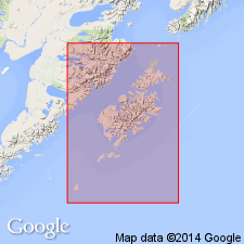
Summary:
Named for Kodiak Island, AK. Type section designated along west shore of Uyak Bay, Kodiak Island, from 4 km south of head of bay to 3 km south of Uyak village. Crops out along center of island in northeast-trending belt about 60 km wide. Also underlies southeastern part of Afognak Island. Is 30,000 m thick at type section. Consists of sequence of 1-m beds, generally slate in upper part of bed and medium-grained sandstone which is locally phyllitic in lower part of bed. All formation boundaries are faults. Intruded by middle Tertiary quartz diorite; Triassic rocks are thrust over youngest part of formation. Age is considered Cretaceous on basis of superposition and fauna (two species of INOCERAMUS from approximately the middle of the unit).
Source: GNU records (USGS DDS-6; Menlo GNULEX).
- Usage in publication:
-
- Kodiak Formation*
- Modifications:
-
- Age modified
- AAPG geologic province:
-
- Alaska Southwestern region
- Kodiak province
Summary:
Graded beds of slate and sandstone of Kodiak Formation shown on Kodiak Island, AK. Age given as Maestrichtian (Jones and Clark, 1973, USGS Journal of Research v.1 no.2 p.125-136)
Source: GNU records (USGS DDS-6; Menlo GNULEX).
For more information, please contact Nancy Stamm, Geologic Names Committee Secretary.
Asterisk (*) indicates published by U.S. Geological Survey authors.
"No current usage" (†) implies that a name has been abandoned or has fallen into disuse. Former usage and, if known, replacement name given in parentheses ( ).
Slash (/) indicates name conflicts with nomenclatural guidelines (CSN, 1933; ACSN, 1961, 1970; NACSN, 1983, 2005, 2021). May be explained within brackets ([ ]).