

- Usage in publication:
-
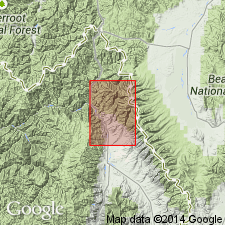
- Kirtley formation
- Modifications:
-
- Named
- Dominant lithology:
-
- Shale
- Sandstone
- AAPG geologic province:
-
- Idaho Mountains province
Summary:
Named for Kirtley Creek, Lemhi Co, ID in the Idaho Mountains province. Replaces name Carmen formation, a name that was applied to all Tertiary sedimentary strata within Salmon basin. The Tertiary sequence called Carmen is divisible into three formations. Present in southern part of quad. Geologic map; cross sections. No type locality designated. Consists of white to gray, moderately well-indurated, thin-bedded, fine-grained rocks--mostly shale some of which is siliceous--, sandstone, and sandy shale. Bentonitic beds at southern localities. Several hundred ft of Kirtley are exposed. Regarded as middle Miocene or younger. Overlies Geertson formation; underlies unnamed Pleistocene deposits.
Source: GNU records (USGS DDS-6; Denver GNULEX).
- Usage in publication:
-
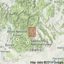
- Kirtley Formation†
- Modifications:
-
- Abandoned
Summary:
Cannot be clearly recognized and consistently mapped in its type area, or in any area adjacent in the Lemhi Valley, Lemhi Co, ID, Idaho Mountains province. Rocks formerly included in Kirtley are mapped as the Tertiary tuffaceous sedimentary rocks in the north part of the Lemhi valley. Name abandoned.
Source: GNU records (USGS DDS-6; Denver GNULEX).
For more information, please contact Nancy Stamm, Geologic Names Committee Secretary.
Asterisk (*) indicates published by U.S. Geological Survey authors.
"No current usage" (†) implies that a name has been abandoned or has fallen into disuse. Former usage and, if known, replacement name given in parentheses ( ).
Slash (/) indicates name conflicts with nomenclatural guidelines (CSN, 1933; ACSN, 1961, 1970; NACSN, 1983, 2005, 2021). May be explained within brackets ([ ]).