The National Geologic Map Database is migrating to a new infrastructure. We apologize for any service disruptions during this process.
|
|---|


- Usage in publication:
-
- Kindblade formation*
- Modifications:
-
- Original reference
- AAPG geologic province:
-
- South Oklahoma folded belt
Summary:
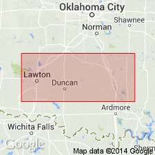
Pg. 15, 16 (table 1), 25-26, 47-48; 1939, GSA Bull., v. 50, no. 8, p. 1313, 1320, table 1. Kindblade formation of Arbuckle group. Name proposed to replace preoccupied Alden (Decker, 1933). Chiefly dark-gray limestones in groups of beds in which one or two thick ones alternate with zones of thinner beds. Thickness near type section about 956 feet; to Arbuckle Mountains aggregates 1,216 to 1,536 feet. Grades Into Cool Creek formation below and West Spring Creek formation above. Age is Early Ordovician.
Type section: outcrop on Kindblade Ranch, in E/2 sec. 26, T. 6 N., R. 14 W., 10.5 mi southwest of Carnegie, Comanche Co., southwestern OK. Well exposed along east side of ranch.
Source: US geologic names lexicon (USGS Bull. 1200, p. 2012).
For more information, please contact Nancy Stamm, Geologic Names Committee Secretary.
Asterisk (*) indicates published by U.S. Geological Survey authors.
"No current usage" (†) implies that a name has been abandoned or has fallen into disuse. Former usage and, if known, replacement name given in parentheses ( ).
Slash (/) indicates name conflicts with nomenclatural guidelines (CSN, 1933; ACSN, 1961, 1970; NACSN, 1983, 2005, 2021). May be explained within brackets ([ ]).