The National Geologic Map Database is migrating to a new infrastructure. We apologize for any service disruptions during this process.
|
|---|


- Usage in publication:
-
- Kimball Mountain Tuff Bed*
- Modifications:
-
- Named
- Areal extent
- Dominant lithology:
-
- Tuff
- AAPG geologic province:
-
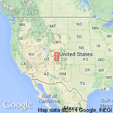
- Piceance basin
Summary:
Named as a bed in the Eocene Green River Formation for Kimball Mountain, Garfield Co, CO in the Piceance basin. Type section measured on west end of Kimball Mountain in SW1/4 SE1/4 sec 7, T7S, R98W. Occurs 60 to 110 m above base of Long Point Bed (new) throughout southwest part of Piceance Creek basin [north of Colorado River]. In thin section tuff consists of hexagonal analcime crystals surrounded by large crystals of sparry calcite. Fresh color is light buff to dark gray. Thickness ranges from 1 to 15 cm. Is the basal tuff or as a bed in the Douglas Creek, Anvil Points, and Parachute Creek Members of Green River. Is in Parachute Creek Member at type. Areal limits of bed to southern part of Piceance Creek basin [north of Colorado River] included. Measured sections; cross sections.
Source: GNU records (USGS DDS-6; Denver GNULEX).
For more information, please contact Nancy Stamm, Geologic Names Committee Secretary.
Asterisk (*) indicates published by U.S. Geological Survey authors.
"No current usage" (†) implies that a name has been abandoned or has fallen into disuse. Former usage and, if known, replacement name given in parentheses ( ).
Slash (/) indicates name conflicts with nomenclatural guidelines (CSN, 1933; ACSN, 1961, 1970; NACSN, 1983, 2005, 2021). May be explained within brackets ([ ]).