

- Usage in publication:
-
- Kent Island Formation*
- Modifications:
-
- Named
- Dominant lithology:
-
- Sand
- Silt
- Gravel
- AAPG geologic province:
-
- Atlantic Coast basin
Summary:
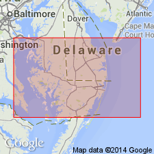
Kent Island Formation is named in east-central MD, where it is exposed along the Chester River, Queen Annes Co. Unit also mapped in DE. This estuarine deposit described as light-colored, cross-bedded sand, clay-silt, and gravel. Tree stumps in growth position are encased within clay-silt. Measures 12 m maximum. Unconformably overlies Chesapeake Group, undivided, Pensauken Formation, Beaverdam Sand, and equivalents of Ironshire and Omar Formations. Age is Pleistocene (Wisconsinan).
Source: GNU records (USGS DDS-6; Reston GNULEX).
- Usage in publication:
-
- Kent Island Formation
- Modifications:
-
- Overview
- AAPG geologic province:
-
- Atlantic Coast basin
Summary:
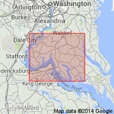
Kent Island Formation in map area described as tan to orange mainly fine- to medium-grained, moderately sorted to poorly sorted silty sand, with minor silty to sandy dewatered clay. Deposits occur along the Potomac River and the lower reaches of other streams, especially on Cobb Neck, Cedar Point Neck, and the head of Zekiah Swamp Run estuary. Thickness typically 5 to 20 ft. Radiocarbon date on wood chips at Goose Bay Aggregate Company's dock south of Chicamuxen Creek is 20,500+/-500 yrs (Rubin and Mixon, written commun., 1986). Peat samples have yielded radiocarbon dates in the range of 24,000 to 37,000 yrs (Owens and Denny, 1978). Correlates with Poquoson, Lynnhaven, and Sinepuxent Formations. In the type area in Queen Annes Co., the Kent Island was originally defined to include two estuarine units. According to Owens (personal commun., 1988), the upper unit containing the dated peat samples, belongs to the Kent Island, but the lower unit should be assigned to the Ironshire Formation. Lower contact with Pleistocene Maryland Point Formation or units as old as Cretaceous is erosional unconformity marked by a layer of pebbles and either root casts or burrows. Underlies Holocene deposits. Age is late Pleistocene. [Nomenclature in this report reflects the usage of the Maryland Geological Survey.]
Source: GNU records (USGS DDS-6; Reston GNULEX).
- Usage in publication:
-
- Kent Island Formation*
- Modifications:
-
- Areal extent
- AAPG geologic province:
-
- Atlantic Coast basin
Summary:
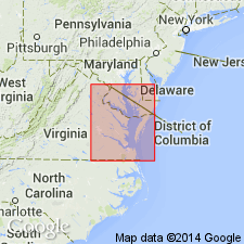
Kent Island Formation is mapped east of Chesapeake Bay in the Coastal Plain of VA. Thickness ranges from featheredge to 40 ft. Overlies late Pleistocene Wachapreague Formation.
Source: GNU records (USGS DDS-6; Reston GNULEX).

- Usage in publication:
-
- Kent Island Formation
- Modifications:
-
- Overview
- AAPG geologic province:
-
- Atlantic Coast basin
Summary:
Nomenclature on State map follows Owens and Denny (1979). Kent Island Formation refers to pale gray to yellowish-gray, medium to coarse sand and sandy gravel grading upward into poorly to well sorted, fine to medium sand, in part clayey and silty. Unit is a surficial deposit of broad, bayward-sloping lowland (altitude ranges from sea level to about 20 ft) bordering east side of Chesapeake Bay. Thickness ranges from a feather-edge at the scarp along eastern edge of lowland to about 40 ft in downdip areas. Overlies Wachapreague Formation. Age is late Pleistocene.
Source: GNU records (USGS DDS-6; Reston GNULEX).
- Usage in publication:
-
- Kent Island Formation
- AAPG geologic province:
-
- Atlantic Coast basin
Ramsey, K.W., 2010, Stratigraphy, correlation, and depositional environments of the middle to late Pleistocene interglacial deposits of southern Delaware: Delaware Geological Survey Report of Investigations, no. 76, 43 p.
Summary:
Pg. 22+. Kent Island Formation of Nanticoke River Group. [Not synopsized to date. See also Ramsey, K.W., 2010, Geol. map Georgetown quadrangle, Delaware Geol. Survey, Geol. Map Ser., no. 15, scale 1:24,000, and references therein.]
Source: NA
For more information, please contact Nancy Stamm, Geologic Names Committee Secretary.
Asterisk (*) indicates published by U.S. Geological Survey authors.
"No current usage" (†) implies that a name has been abandoned or has fallen into disuse. Former usage and, if known, replacement name given in parentheses ( ).
Slash (/) indicates name conflicts with nomenclatural guidelines (CSN, 1933; ACSN, 1961, 1970; NACSN, 1983, 2005, 2021). May be explained within brackets ([ ]).