

- Usage in publication:
-
- Kennel Creek limestone*
- Modifications:
-
- Named
- Biostratigraphic dating
- Dominant lithology:
-
- Limestone
- Dolomite
- AAPG geologic province:
-
- Alaska Southeastern region
Summary:
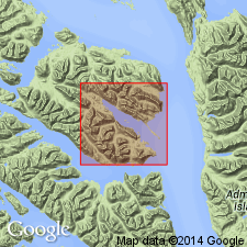
Named for typical exposures on southwest shore of Freshwater Bay southeast and northwest of mouth of Kennel Creek, Freshwater Bay area, Chichagof Island, southeastern AK. Measured type section designated along beach from point about 0.75 mi southeast of mouth of Kennel Creek to point about 0.25 mi northwest of creek. Exposed on both limbs of Freshwater Bay syncline. Consists of dark- and light-gray fossiliferous, thick-bedded to massive limestone with dolomite beds in lower part of unit west and north of type locality. Upper part is thin-bedded limestone with tuffaceous partings. Thickness averages about 3500 ft. Base of limestone is cut off by fault at type section. Overlies Silurian(?) or Devonian(?) argillite and graywacke sequence. In lower part of Wukuklook Creek is apparently thrust over Iyoukeen formation (new). Grades upward into Cedar Cove formation (new). Age is Middle Devonian based on AMPHIPORA and PYCINODESMA at type section.
Source: GNU records (USGS DDS-6; Menlo GNULEX).
- Usage in publication:
-
- Kennel Creek Limestone*
- Modifications:
-
- Age modified
- Biostratigraphic dating
- Areal extent
- AAPG geologic province:
-
- Alaska Southeastern region
Summary:
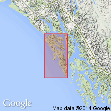
Geographically extended to include apparently correlative strata outside area as mapped by Loney and others (1963). Age is Silurian and (or) Devonian on basis of re-evaluation of age range of previous fauna.
Source: GNU records (USGS DDS-6; Menlo GNULEX).
For more information, please contact Nancy Stamm, Geologic Names Committee Secretary.
Asterisk (*) indicates published by U.S. Geological Survey authors.
"No current usage" (†) implies that a name has been abandoned or has fallen into disuse. Former usage and, if known, replacement name given in parentheses ( ).
Slash (/) indicates name conflicts with nomenclatural guidelines (CSN, 1933; ACSN, 1961, 1970; NACSN, 1983, 2005, 2021). May be explained within brackets ([ ]).