

- Usage in publication:
-
- Kennedy gravels*
- Modifications:
-
- Original reference
- Dominant lithology:
-
- Gravel
- AAPG geologic province:
-
- Montana folded belt
Summary:
Pg. 315, 328-330. Kennedy gravels. Well-rounded or subangular high-level gravel of local origin; rarely boulders 2 feet across occur; those 6 to 12 inches diameter are common. Finer gravel and gravelly soil make up the mass. Obscurely stratified; glacial striae absent. Thickness 100+ feet; base not seen. Believed to be a remnant of an alluvial cone of Kennedy Creek. Rest on Benton shale. Description largely compiled from notes by G.I. Finlay.
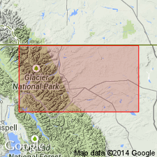
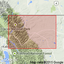
Type locality: a gravel mesa, 5,800 feet high, 5 mi east of Chief Mountain, north of Kennedy Creek and 900 ft above it, in northwestern part of Teton Co., northwestern MT. Age is Pleistocene or Pliocene (p. 315); Pleistocene(?) (p. 328).
Source: US geologic names lexicon (USGS Bull. 896, p. 1081); supplemental information from GNU records (USGS DDS-6; Denver GNULEX).

- Usage in publication:
-
- Kennedy gravels†
- Modifications:
-
- Abandoned
- AAPG geologic province:
-
- Sweetgrass arch
Summary:
W.C. Alden (personal communication June 1932), who found glaciated material in typical †Kennedy gravels on Kennedy Ridge, regards the deposit as of glacial origin, and includes it in his pre-Wisconsin glacial drift. (See also W.C. Alden, USGS Prof. Paper 173, 1932).
Source: US geologic names lexicon (USGS Bull. 896, p. 1081).
- Usage in publication:
-
- Kennedy drift*
- Modifications:
-
- Reinstated
- AAPG geologic province:
-
- Sweetgrass arch
Summary:
Pg. 1102. Kennedy drift. Pre-Wisconsin Mountain drift of Glacier Park was described by Willis (1902) as Kennedy gravels and considered a fluvial deposit. Alden (1932, USGS Prof. Paper 174) determined its glacial origin and included it in his pre-Wisconsin Mountain drift. Inasmuch as references are clearly to same deposits, original name should be retained. Kennedy drift, which is at least 100 feet thick, includes both till and outwash and in places is cemented by calcium carbonate into tillite and conglomerate. Upper 20 feet in places is weathered and leached, so that residue of insoluble pebbles occur in yellow-brown, limonitic, clayey matrix. Age is Pleistocene (pre-Wisconsin).
Source: US geologic names lexicon (USGS Bull. 1200, p. 1990).
- Usage in publication:
-
- Kennedy drift*
- Modifications:
-
- Areal extent
- AAPG geologic province:
-
- Sweetgrass arch
Summary:
Kennedy drift. Discussion of correlation of alpine and continental glacial deposits of Glacier Nattonal Park and adjacent high plains, Montana. Three alpine glaciations occurred. Tills of these three ancient glaciers are all included in Kennedy drift of Horberg (1954). They have no continental counterparts in this region but are correlated with Nebraskan, Kansan, and Illinoian tills of central interior.
Source: US geologic names lexicon (USGS Bull. 896, p. 1990).
- Usage in publication:
-
- Kennedy Formation*
- Modifications:
-
- Age modified
- Redescribed
- Dominant lithology:
-
- Till
- Gravel
- AAPG geologic province:
-
- Montana folded belt
- Sweetgrass arch
Summary:
Redescribed from Kennedy Till to Kennedy Formation. Includes three superposed bouldery tills separated by and overlain by thick weathered zones, and associated outwash gravel and related deposits. A U-trend age of 440 +/-120 ka obtained from upper till. Shown as a pre-Illinoian, early middle Pleistocene to middle middle Pleistocene unit ranging from less than 782,000 yrs for base of lower till to about 428,000 yrs for top of upper till. Known in the Glacier Park area, MT, Montana folded belt province and Sweetgrass arch.
Source: GNU records (USGS DDS-6; Denver GNULEX).
For more information, please contact Nancy Stamm, Geologic Names Committee Secretary.
Asterisk (*) indicates published by U.S. Geological Survey authors.
"No current usage" (†) implies that a name has been abandoned or has fallen into disuse. Former usage and, if known, replacement name given in parentheses ( ).
Slash (/) indicates name conflicts with nomenclatural guidelines (CSN, 1933; ACSN, 1961, 1970; NACSN, 1983, 2005, 2021). May be explained within brackets ([ ]).