The National Geologic Map Database is migrating to a new infrastructure. We apologize for any service disruptions during this process.
|
|---|


- Usage in publication:
-
- Kennebago Member*
- Modifications:
-
- Named
- Dominant lithology:
-
- Slate
- Quartzite
- Greenstone
- AAPG geologic province:
-
- New England province
Summary:
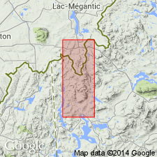
Named for abandoned logging settlement of Kennebago, Franklin Co., western ME. Named as a member of Albee Formation. Type locality is along Kennebago River, about 0.5 mi downstream from dam at outlet of Kennebago Lake. Crops out in a narrow belt trending southwest from type locality and curving to the west around Cupsuptic pluton; west of the pluton, Kennebago Member forms two narrow bands of varying trend. Consists of red, maroon, purplish-gray, and minor green slate that contains 10 to 50 percent feldspathic quartzite and quartzite and sparse, discontinuous lenses of black slate and greenstone. Thickness is about 4,500 ft. Underlies Portage Brook Member of Albee Formation; lower contact is not exposed. Report includes geologic map. Age is Early and Middle Ordovician.
Source: GNU records (USGS DDS-6; Reston GNULEX).
For more information, please contact Nancy Stamm, Geologic Names Committee Secretary.
Asterisk (*) indicates published by U.S. Geological Survey authors.
"No current usage" (†) implies that a name has been abandoned or has fallen into disuse. Former usage and, if known, replacement name given in parentheses ( ).
Slash (/) indicates name conflicts with nomenclatural guidelines (CSN, 1933; ACSN, 1961, 1970; NACSN, 1983, 2005, 2021). May be explained within brackets ([ ]).