

- Usage in publication:
-
- Kendall Mountain Formation
- Modifications:
-
- First used
- Dominant lithology:
-
- Sandstone
- Graywacke
- Conglomerate
- Siltstone
- Metasandstone
- Tuff
- AAPG geologic province:
-
- New England province
Summary:
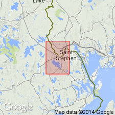
Kendall Mountain Formation is here informally named and assigned as one of four subdivisions to the Wapsaconhagan Brook Group (new [informal] name) in eastern ME. Rocks were previously mapped as an informal member of the Cookson Formation (Ludman, 1985), which is here stratigraphically restricted in the study area. Kendall Mountain contains the most varied lithologic assemblage of the group including quartz arenites; quartzofeldspathic and lithic arenites, wackes, and granule conglomerates; subordinate horizons of thinly interbedded siltstone and carbonaceous pelite; and a unique horizon of felsic tuffs. It is the only unit of the Wapsaconhagan Brook to contain significant volcanic material and the only unit to contain insignificant amounts (less than 5%) of pelite. Also unlike the other units, the psammites do not produce biotite even at elevated metamorphic grade. Most of the formation is composed of thick-bedded metasandstones, commonly massive and non-graded. Thickness is estimated between 500 and 800 m. Unit overlies thin-bedded pelites of the Pocomoonshine Lake Formation and underlies Woodland Formation (new [informal] names), both of Wapsaconhagan Brook Group. Correlates with Agnostus Cove Formation in the East St. John area, CAN. Inferred age is Cambrian based on intrusion of Baileyville dike (Cambrian-Ordovician and stratigraphic position below the Cookson Formation (earliest Ordovician).
Source: GNU records (USGS DDS-6; Reston GNULEX).

- Usage in publication:
-
- Kendall Mountain Formation
- Modifications:
-
- Named
- Dominant lithology:
-
- Sandstone
- Conglomerate
- Shale
- Siltstone
- Volcanics
- AAPG geologic province:
-
- New England province
Summary:
Kendall Mountain Formation is here formally named and assigned to the Cookson Group (rank raised) in southeastern ME. Contains several kinds of sandstone (quartz, quartz-feldspar, and lithic arenites and wackes), granule and pebble conglomerates, and very minor felsic volcanic rocks in addition to black shale and siltstone. Crops out on northwestern slope of Kendall Mountain (type locality) and in lowlands between that mountain and Pocomoonshine Lake. Also underlies a large area west of the St. Croix River just north of Woodland. Gradationally overlies the Pocomoonshine Lake Formation (new name) and underlies the Woodland Formation (new name), both of Cookson Group. Thickness is estimated to be between 500 and 700 m. Age is Late Cambrian based on stratigraphic position below the youngest unit in the Cookson, the Early Ordovician Calais Formation (new name). [Oral commun. with Ludman, 5/89, confirms informal status of unit in 1986 open-file report]
Source: GNU records (USGS DDS-6; Reston GNULEX).
- Usage in publication:
-
- Kendall Mountain Formation
- Modifications:
-
- Revised
- Age modified
- Biostratigraphic dating
- AAPG geologic province:
-
- New England province
Summary:
Stratigraphic order of the formations within the Cookson Group is here revised based on new fossil evidence. Ascending, these units are Calais, Woodland, Pocomoonshine Lake, and Kendall Mountain Formations. The Digdeguash, previously considered Silurian, is here included in the Cookson as an equivalent of the Woodland and Pocomoonshine Lake Formations. Kendall Mountain, once thought to be Cambrian and placed at the base of the Cookson, contains Caradocian graptolites and is now considered the youngest preserved part of the Group. [Author equates Caradocian with Middle Ordovician. According to Elsevier (1987) Caradocian is Late Ordovician.] Calais Formation, at the base of the Cookson, has been dated as Arenigian. Woodland, once inferred to be Late Cambrian, now believed to be Ordovician based on its conformable contact with the overlying Kendall Mountain. Therefore, Cookson ranges from Early to Middle [Late] Ordovician.
Source: GNU records (USGS DDS-6; Reston GNULEX).

- Usage in publication:
-
- Kendall Mountain Formation
- Modifications:
-
- Overview
- AAPG geologic province:
-
- New England province
Summary:
Author disagrees, in part, with revisions of Cookson proposed by Fyffe and Riva (1990). Though he agrees that fossil evidence requires inversion of the stratigraphic sequence, he states that the Pocomoonshine Lake and Digdeguash formations are more likely a part of the Fredericton belt rather than of the St. Croix terrane and therefore are not part of the Cookson Group. Interpretation is based on lithologic and structural evidence. As here revised the Late Cambrian(?) to Middle Ordovician Cookson comprises (ascending) Calais, Woodland, and Kendall Mountain Formations. Author states there is no evidence for the correlation of the Digdeguash and Woodland Formations proposed by Fyffe and Riva (1990). Cookson Group tectonically underlies Pocomoonshine Lake Formation, which conformably underlies Digdeguash. Digdeguash is here assigned a Silurian age and underlies Silurian and Devonian Flume Ridge Formation.
Source: GNU records (USGS DDS-6; Reston GNULEX).
- Usage in publication:
-
- Kendall Mountain Formation
- Modifications:
-
- Overview
- AAPG geologic province:
-
- New England province
Summary:
Pocomoonshine Gabbro-Diorite intrudes the Pocomoonshine Lake, Digdeguash, and Flume Ridge Formations in the Fredericton belt and cuts the Kendall Mountain and Woodland Formations of the Cookson Group in the St. Croix belt. The pluton was emplaced during two separate episodes during the Silurian Period. 40Ar/39Ar hornblende ages form the northern mafic portion indicate crystallization at 422.7+/-3.0 Ma. Muscovite plateau age of 414.2+/-3.2 Ma is minimum age for central and southern dioritic portions of the pluton. Therefore, deposition of the Pocomoonshine Lake, Digdeguash, and Flume Ridge Formations is constrained to Late Caradocian (early Late Ordovician) through Early Silurian. The Cookson Group is interpreted as Late Cambrian(?) through Late Ordovician. Kendall Mountain Formation at the top of the Group is shown as Middle and Late Ordovician. According to authors, a major episode of folding and regional metamorphism must have taken place during the Silurian. Melding of the Fredericton, St. Croix, and Coastal Volcanic belts into a single block must have occurred by the Silurian. Accretion of this composite block to ancestral North America, then, was probably responsible for the Acadian Orogeny in northern New England.
Source: GNU records (USGS DDS-6; Reston GNULEX).
For more information, please contact Nancy Stamm, Geologic Names Committee Secretary.
Asterisk (*) indicates published by U.S. Geological Survey authors.
"No current usage" (†) implies that a name has been abandoned or has fallen into disuse. Former usage and, if known, replacement name given in parentheses ( ).
Slash (/) indicates name conflicts with nomenclatural guidelines (CSN, 1933; ACSN, 1961, 1970; NACSN, 1983, 2005, 2021). May be explained within brackets ([ ]).