

- Usage in publication:
-
- Kemik sandstone member*
- Modifications:
-
- Named
- Dominant lithology:
-
- Sandstone
- AAPG geologic province:
-
- Alaska Northern region
Summary:
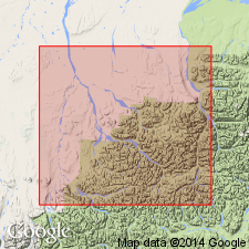
Named as basal member of Okpikruak formation. Measured type section is on east side of Kemik Creek between 69 deg 24'N and 69 deg 25'N. Extends from Echooka River to Kavik River. Forms faulted rubble ridges and apparently pinches out both to west and east. Composed of quartzose fine- to medium-grained, sugary-textured light-gray sandstone. Is 220 ft thick at type. Overlies Jurassic shale. Fossils collected from unit are not age diagnostic but age of member is considered to be Early Cretaceous based on age of Okpikruak formation.
Source: GNU records (USGS DDS-6; Menlo GNULEX).
- Usage in publication:
-
- Kemik Sandstone Member*
- Modifications:
-
- Revised
- AAPG geologic province:
-
- Alaska Northern region
Summary:
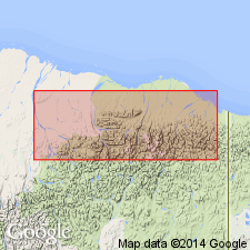
Rocks of Okpikruak Formation in northeast AK are renamed Kongakut Formation because lithology is dissimilar to that of Okpikruak in its type locality. Kemik Sandstone member is reassigned to Kongakut Formation. Sandstone along west side of Canning River near Shublik Springs considered by Keller and others (1961) to be lower part of Ignek Formation is here considered to be Kemik Sandstone member (Ignek Formation is abandoned). At type section of Kongakut, north of Bathtub Ridge, Kemik Sandstone Member overlies clay shale member and underlies pebble shale member (both of Kongakut Formation). Upper part of Kemik Sandstone Member contains sparse megafauna of Early Cretaceous age.
Source: GNU records (USGS DDS-6; Menlo GNULEX).
- Usage in publication:
-
- Kemik Sandstone*
- Modifications:
-
- Revised
- AAPG geologic province:
-
- Alaska Northern region
Summary:
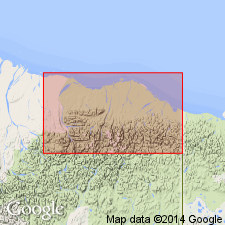
Kemik Sandstone Member raised to: Kemik Sandstone in area "along the mountain front and coastal plain" (area around Sadlerochit Mountains and in a southwesterly band along the Brooks Range foothills and coastal plain as far as the Echooka River, 40 mi southwest of Sadlerochit Mountains). Also occurs in several wells along the foothills as far as 70 mi west of the Canning River. Unconformably overlies progressively older units from south to north. [Still known as Kemik Sandstone member ONLY in the Bathtub Ridge area 60 mi southeast of Sadlerochit Mountains.] Unit age is Early Cretaceous (Hauterivian).
Source: GNU records (USGS DDS-6; Menlo GNULEX).
- Usage in publication:
-
- Kemik Sandstone
- Modifications:
-
- Revised
- Overview
- AAPG geologic province:
-
- Alaska Northern region
Summary:
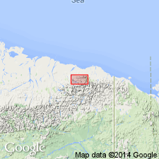
Kemik Sandstone (redefined as formational unit) on north side of Brooks Range includes two new named members, Ignek Valley (cross-bedded sandstone) and Marsh Creek (burrowed pebbly siltstone) Members and unnamed mudstone and shale facies. Detailed lithology, stratigraphic columns and cross sections, fossil lists with localities, depositional environment ... included in report.
Source: GNU records (USGS DDS-6; Menlo GNULEX).
For more information, please contact Nancy Stamm, Geologic Names Committee Secretary.
Asterisk (*) indicates published by U.S. Geological Survey authors.
"No current usage" (†) implies that a name has been abandoned or has fallen into disuse. Former usage and, if known, replacement name given in parentheses ( ).
Slash (/) indicates name conflicts with nomenclatural guidelines (CSN, 1933; ACSN, 1961, 1970; NACSN, 1983, 2005, 2021). May be explained within brackets ([ ]).